You are here: Home > Network List > US - United States National Seismic Network Stations List
> Station MNTX Cornudas Mountains, Texas, USA > Earthquake Result Viewer
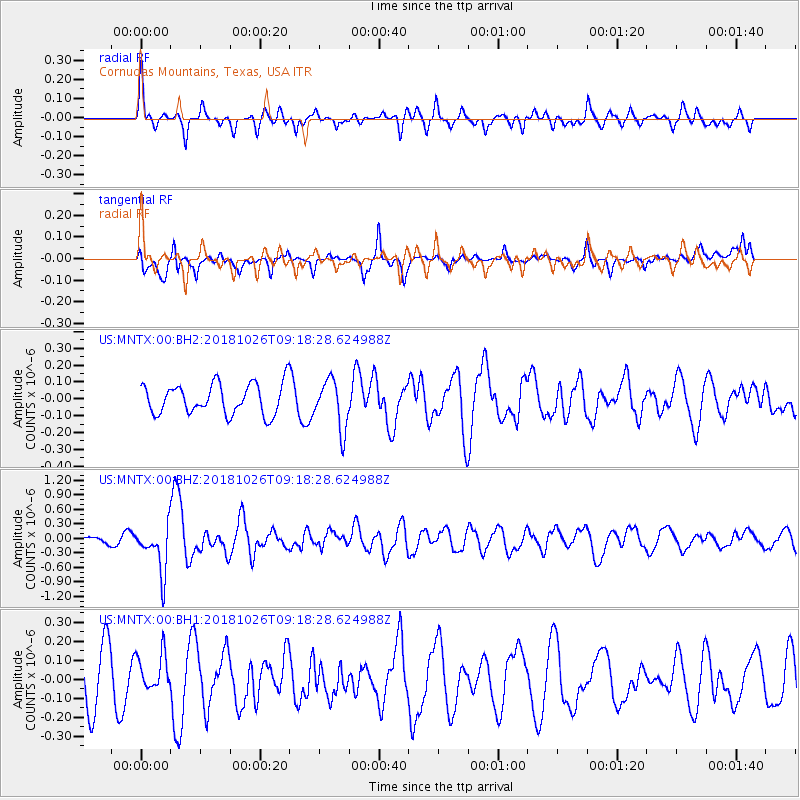
MNTX Cornudas Mountains, Texas, USA - Earthquake Result Viewer
*The percent match for this event was below the threshold and hence no stack was calculated.
| Earthquake location: |
Mariana Islands Region |
| Earthquake latitude/longitude: |
17.4/147.9 |
| Earthquake time(UTC): |
2018/10/26 (299) 09:05:39 GMT |
| Earthquake Depth: |
10 km |
| Earthquake Magnitude: |
5.7 mww |
| Earthquake Catalog/Contributor: |
NEIC PDE/us |
|
| Network: |
US United States National Seismic Network |
| Station: |
MNTX Cornudas Mountains, Texas, USA |
| Lat/Lon: |
31.70 N/105.38 W |
| Elevation: |
404 m |
|
| Distance: |
94.5 deg |
| Az: |
54.969 deg |
| Baz: |
293.461 deg |
| Ray Param: |
$rayparam |
*The percent match for this event was below the threshold and hence was not used in the summary stack. |
|
| Radial Match: |
60.7109 % |
| Radial Bump: |
372 |
| Transverse Match: |
55.43516 % |
| Transverse Bump: |
365 |
| SOD ConfigId: |
3103472 |
| Insert Time: |
2018-11-09 17:12:43.178 +0000 |
| GWidth: |
2.5 |
| Max Bumps: |
400 |
| Tol: |
0.001 |
|
Signal To Noise
| Channel | StoN | STA | LTA |
| US:MNTX:00:BHZ:20181026T09:18:28.624988Z | 4.1960545 | 4.850642E-7 | 1.1560007E-7 |
| US:MNTX:00:BH1:20181026T09:18:28.624988Z | 0.7499649 | 9.890729E-8 | 1.3188256E-7 |
| US:MNTX:00:BH2:20181026T09:18:28.624988Z | 1.626484 | 1.4533897E-7 | 8.935777E-8 |
| Arrivals |
| Ps | |
| PpPs | |
| PsPs/PpSs | |


