You are here: Home > Network List > UU - University of Utah Regional Network Stations List
> Station CVRU Castle Valley Ranch, Emery, UT, USA old TA-Q16A > Earthquake Result Viewer
CVRU Castle Valley Ranch, Emery, UT, USA old TA-Q16A - Earthquake Result Viewer
| Earthquake location: |
Mariana Islands Region |
| Earthquake latitude/longitude: |
17.4/147.9 |
| Earthquake time(UTC): |
2018/10/26 (299) 09:05:39 GMT |
| Earthquake Depth: |
10 km |
| Earthquake Magnitude: |
5.7 mww |
| Earthquake Catalog/Contributor: |
NEIC PDE/us |
|
| Network: |
UU University of Utah Regional Network |
| Station: |
CVRU Castle Valley Ranch, Emery, UT, USA old TA-Q16A |
| Lat/Lon: |
38.92 N/111.17 W |
| Elevation: |
1912 m |
|
| Distance: |
87.5 deg |
| Az: |
50.054 deg |
| Baz: |
290.208 deg |
| Ray Param: |
0.04330548 |
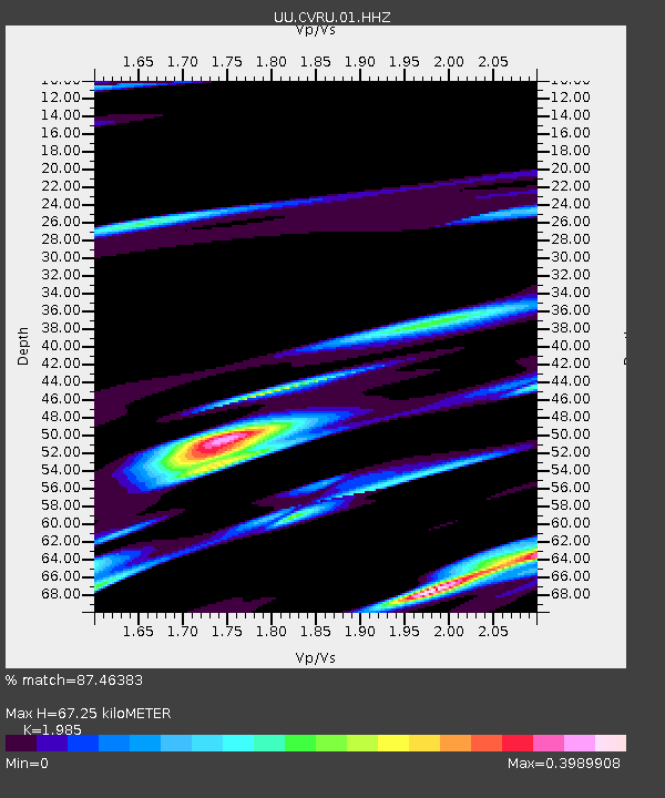
| Estimated Moho Depth: |
67.25 km |
| Estimated Crust Vp/Vs: |
1.99 |
| Assumed Crust Vp: |
6.207 km/s |
| Estimated Crust Vs: |
3.127 km/s |
| Estimated Crust Poisson's Ratio: |
0.33 |
|
| Radial Match: |
87.46383 % |
| Radial Bump: |
364 |
| Transverse Match: |
59.834743 % |
| Transverse Bump: |
373 |
| SOD ConfigId: |
3103472 |
| Insert Time: |
2018-11-09 17:13:07.183 +0000 |
| GWidth: |
2.5 |
| Max Bumps: |
400 |
| Tol: |
0.001 |
|
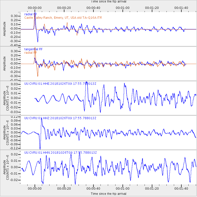
Signal To Noise
| Channel | StoN | STA | LTA |
| UU:CVRU:01:HHZ:20181026T09:17:55.788013Z | 10.288334 | 5.093999E-8 | 4.951238E-9 |
| UU:CVRU:01:HHN:20181026T09:17:55.788013Z | 1.5174522 | 9.322282E-9 | 6.1433774E-9 |
| UU:CVRU:01:HHE:20181026T09:17:55.788013Z | 1.962046 | 1.06634275E-8 | 5.434851E-9 |
| Arrivals |
| Ps | 11 SECOND |
| PpPs | 32 SECOND |
| PsPs/PpSs | 43 SECOND |


