You are here: Home > Network List > UU - University of Utah Regional Network Stations List
> Station FORU South Mineral Mountains, UT, USA > Earthquake Result Viewer
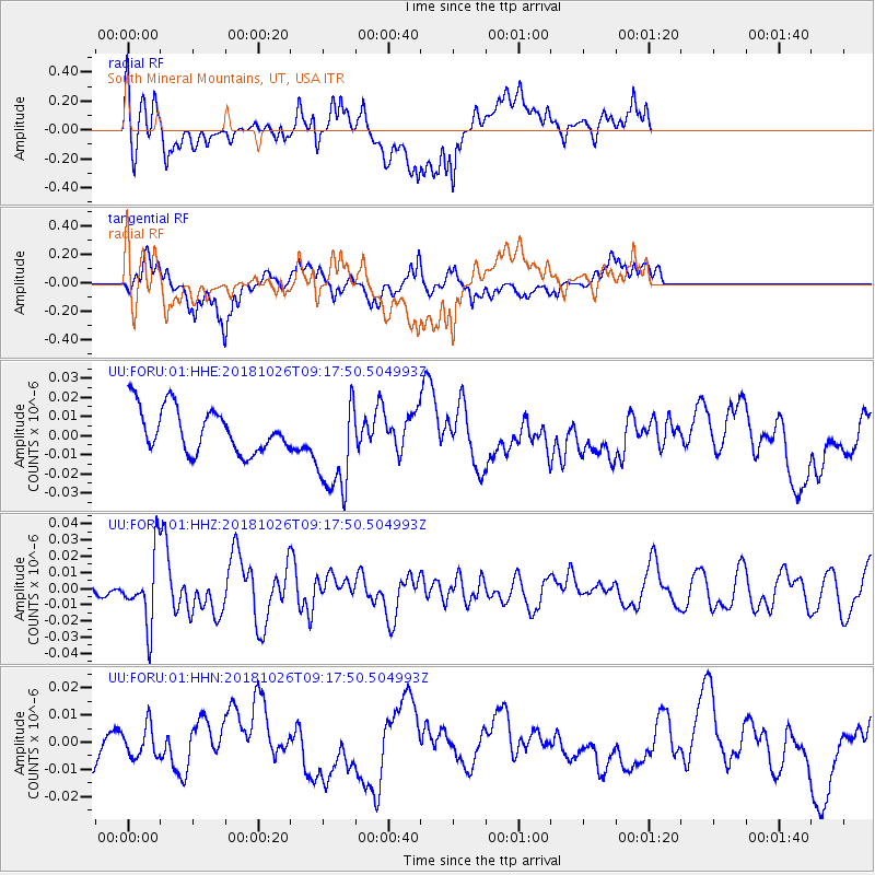
FORU South Mineral Mountains, UT, USA - Earthquake Result Viewer
*The percent match for this event was below the threshold and hence no stack was calculated.
| Earthquake location: |
Mariana Islands Region |
| Earthquake latitude/longitude: |
17.4/147.9 |
| Earthquake time(UTC): |
2018/10/26 (299) 09:05:39 GMT |
| Earthquake Depth: |
10 km |
| Earthquake Magnitude: |
5.7 mww |
| Earthquake Catalog/Contributor: |
NEIC PDE/us |
|
| Network: |
UU University of Utah Regional Network |
| Station: |
FORU South Mineral Mountains, UT, USA |
| Lat/Lon: |
38.46 N/112.86 W |
| Elevation: |
1840 m |
|
| Distance: |
86.4 deg |
| Az: |
50.932 deg |
| Baz: |
289.203 deg |
| Ray Param: |
$rayparam |
*The percent match for this event was below the threshold and hence was not used in the summary stack. |
|
| Radial Match: |
56.400253 % |
| Radial Bump: |
400 |
| Transverse Match: |
49.310455 % |
| Transverse Bump: |
400 |
| SOD ConfigId: |
3103472 |
| Insert Time: |
2018-11-09 17:13:16.028 +0000 |
| GWidth: |
2.5 |
| Max Bumps: |
400 |
| Tol: |
0.001 |
|
Signal To Noise
| Channel | StoN | STA | LTA |
| UU:FORU:01:HHZ:20181026T09:17:50.504993Z | 2.880775 | 2.1208397E-8 | 7.3620456E-9 |
| UU:FORU:01:HHN:20181026T09:17:50.504993Z | 0.92598015 | 5.9058367E-9 | 6.37793E-9 |
| UU:FORU:01:HHE:20181026T09:17:50.504993Z | 2.2873354 | 2.6354337E-8 | 1.1521851E-8 |
| Arrivals |
| Ps | |
| PpPs | |
| PsPs/PpSs | |


