You are here: Home > Network List > TA - USArray Transportable Network (new EarthScope stations) Stations List
> Station 435B Jarrell, TX, USA > Earthquake Result Viewer
435B Jarrell, TX, USA - Earthquake Result Viewer

| Earthquake location: |
Near Coast Of Central Chile |
| Earthquake latitude/longitude: |
-36.2/-73.3 |
| Earthquake time(UTC): |
2010/03/16 (075) 02:21:57 GMT |
| Earthquake Depth: |
18 km |
| Earthquake Magnitude: |
6.0 MB, 6.7 MS, 6.7 MW, 6.6 MW |
| Earthquake Catalog/Contributor: |
WHDF/NEIC |
|
| Network: |
TA USArray Transportable Network (new EarthScope stations) |
| Station: |
435B Jarrell, TX, USA |
| Lat/Lon: |
30.78 N/97.58 W |
| Elevation: |
248 m |
|
| Distance: |
70.5 deg |
| Az: |
337.9 deg |
| Baz: |
159.298 deg |
| Ray Param: |
0.054957233 |
| Estimated Moho Depth: |
11.0 km |
| Estimated Crust Vp/Vs: |
1.97 |
| Assumed Crust Vp: |
6.347 km/s |
| Estimated Crust Vs: |
3.23 km/s |
| Estimated Crust Poisson's Ratio: |
0.33 |
|
| Radial Match: |
93.35614 % |
| Radial Bump: |
386 |
| Transverse Match: |
55.434315 % |
| Transverse Bump: |
400 |
| SOD ConfigId: |
308276 |
| Insert Time: |
2010-06-22 20:37:15.953 +0000 |
| GWidth: |
2.5 |
| Max Bumps: |
400 |
| Tol: |
0.001 |
|
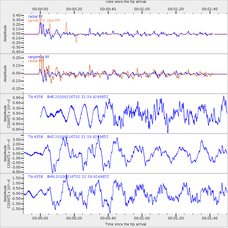
Signal To Noise
| Channel | StoN | STA | LTA |
| TA:435B: :BHZ:20100316T02:32:39.924985Z | 4.9487453 | 9.262797E-7 | 1.8717466E-7 |
| TA:435B: :BHN:20100316T02:32:39.924985Z | 2.2611516 | 2.605402E-7 | 1.1522455E-7 |
| TA:435B: :BHE:20100316T02:32:39.924985Z | 1.6276472 | 4.2796086E-7 | 2.629322E-7 |
| Arrivals |
| Ps | 1.7 SECOND |
| PpPs | 5.0 SECOND |
| PsPs/PpSs | 6.7 SECOND |


