You are here: Home > Network List > TA - USArray Transportable Network (new EarthScope stations) Stations List
> Station 340A Bronson, TX, USA > Earthquake Result Viewer
340A Bronson, TX, USA - Earthquake Result Viewer
| Earthquake location: |
Near Coast Of Central Chile |
| Earthquake latitude/longitude: |
-36.2/-73.3 |
| Earthquake time(UTC): |
2010/03/16 (075) 02:21:57 GMT |
| Earthquake Depth: |
18 km |
| Earthquake Magnitude: |
6.0 MB, 6.7 MS, 6.7 MW, 6.6 MW |
| Earthquake Catalog/Contributor: |
WHDF/NEIC |
|
| Network: |
TA USArray Transportable Network (new EarthScope stations) |
| Station: |
340A Bronson, TX, USA |
| Lat/Lon: |
31.42 N/93.89 W |
| Elevation: |
57 m |
|
| Distance: |
70.0 deg |
| Az: |
341.302 deg |
| Baz: |
162.348 deg |
| Ray Param: |
0.055251993 |
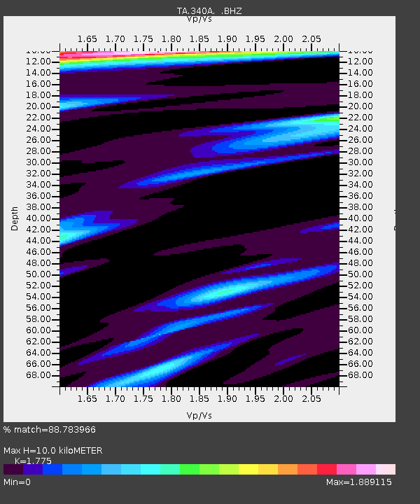
| Estimated Moho Depth: |
10.0 km |
| Estimated Crust Vp/Vs: |
1.77 |
| Assumed Crust Vp: |
6.065 km/s |
| Estimated Crust Vs: |
3.417 km/s |
| Estimated Crust Poisson's Ratio: |
0.27 |
|
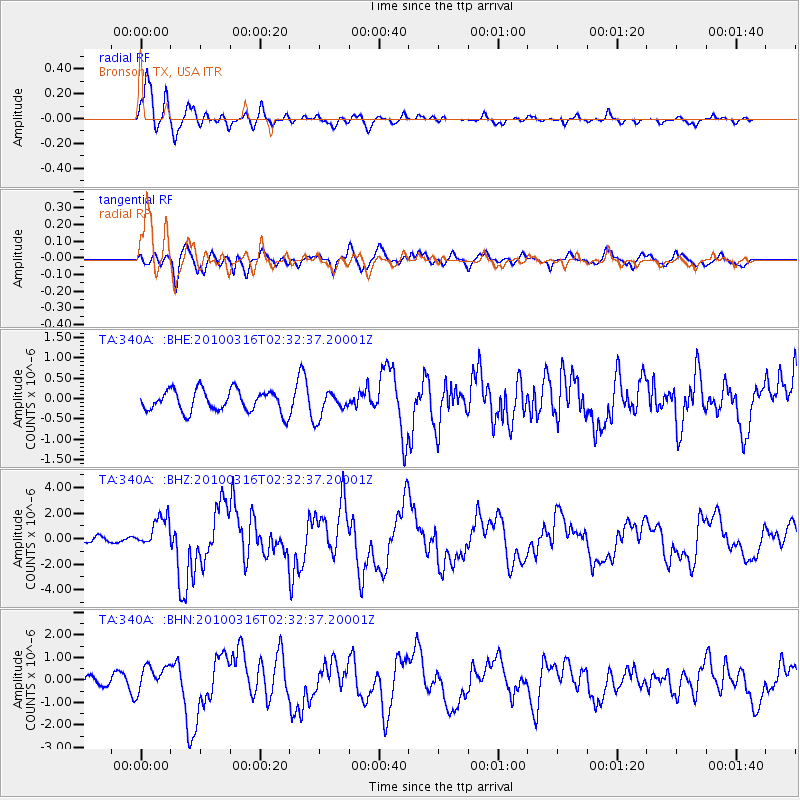
| Radial Match: |
88.783966 % |
| Radial Bump: |
391 |
| Transverse Match: |
67.9256 % |
| Transverse Bump: |
400 |
| SOD ConfigId: |
308276 |
| Insert Time: |
2010-06-22 20:38:24.489 +0000 |
| GWidth: |
2.5 |
| Max Bumps: |
400 |
| Tol: |
0.001 |
|
Signal To Noise
| Channel | StoN | STA | LTA |
| TA:340A: :BHZ:20100316T02:32:37.20001Z | 5.768366 | 1.2428627E-6 | 2.1546184E-7 |
| TA:340A: :BHN:20100316T02:32:37.20001Z | 1.603387 | 5.739842E-7 | 3.5798232E-7 |
| TA:340A: :BHE:20100316T02:32:37.20001Z | 1.1846501 | 3.1188827E-7 | 2.6327461E-7 |
| Arrivals |
| Ps | 1.3 SECOND |
| PpPs | 4.4 SECOND |
| PsPs/PpSs | 5.7 SECOND |


