You are here: Home > Network List > AK - Alaska Regional Network Stations List
> Station E22K Anaktuvuk Pass, AK, USA > Earthquake Result Viewer
E22K Anaktuvuk Pass, AK, USA - Earthquake Result Viewer
| Earthquake location: |
Southeast Of Honshu, Japan |
| Earthquake latitude/longitude: |
33.4/139.3 |
| Earthquake time(UTC): |
2023/05/14 (134) 10:11:35 GMT |
| Earthquake Depth: |
14 km |
| Earthquake Magnitude: |
5.6 mww |
| Earthquake Catalog/Contributor: |
NEIC PDE/us |
|
| Network: |
AK Alaska Regional Network |
| Station: |
E22K Anaktuvuk Pass, AK, USA |
| Lat/Lon: |
68.13 N/151.81 W |
| Elevation: |
772 m |
|
| Distance: |
51.6 deg |
| Az: |
26.476 deg |
| Baz: |
264.565 deg |
| Ray Param: |
0.06730037 |
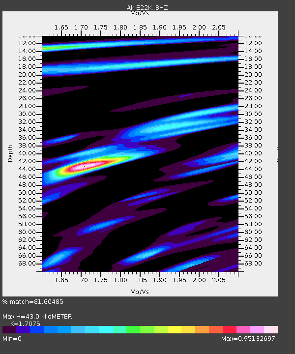
| Estimated Moho Depth: |
43.0 km |
| Estimated Crust Vp/Vs: |
1.71 |
| Assumed Crust Vp: |
6.221 km/s |
| Estimated Crust Vs: |
3.643 km/s |
| Estimated Crust Poisson's Ratio: |
0.24 |
|
| Radial Match: |
81.60485 % |
| Radial Bump: |
361 |
| Transverse Match: |
62.64267 % |
| Transverse Bump: |
400 |
| SOD ConfigId: |
30536071 |
| Insert Time: |
2023-05-28 10:14:06.090 +0000 |
| GWidth: |
2.5 |
| Max Bumps: |
400 |
| Tol: |
0.001 |
|

Signal To Noise
| Channel | StoN | STA | LTA |
| AK:E22K: :BHZ:20230514T10:20:10.260005Z | 3.0135875 | 2.3311028E-7 | 7.7353086E-8 |
| AK:E22K: :BHN:20230514T10:20:10.260005Z | 1.0471288 | 6.323272E-8 | 6.038676E-8 |
| AK:E22K: :BHE:20230514T10:20:10.260005Z | 2.4961054 | 1.02028714E-7 | 4.087516E-8 |
| Arrivals |
| Ps | 5.2 SECOND |
| PpPs | 18 SECOND |
| PsPs/PpSs | 23 SECOND |


