You are here: Home > Network List > CN - Canadian National Seismograph Network Stations List
> Station INK INUVIK, NT > Earthquake Result Viewer
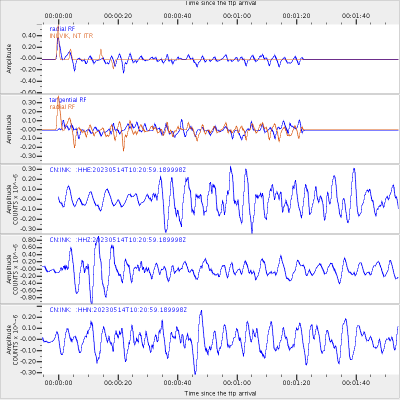
INK INUVIK, NT - Earthquake Result Viewer
*The percent match for this event was below the threshold and hence no stack was calculated.
| Earthquake location: |
Southeast Of Honshu, Japan |
| Earthquake latitude/longitude: |
33.4/139.3 |
| Earthquake time(UTC): |
2023/05/14 (134) 10:11:35 GMT |
| Earthquake Depth: |
14 km |
| Earthquake Magnitude: |
5.6 mww |
| Earthquake Catalog/Contributor: |
NEIC PDE/us |
|
| Network: |
CN Canadian National Seismograph Network |
| Station: |
INK INUVIK, NT |
| Lat/Lon: |
68.31 N/133.53 W |
| Elevation: |
44 m |
|
| Distance: |
58.4 deg |
| Az: |
25.851 deg |
| Baz: |
281.193 deg |
| Ray Param: |
$rayparam |
*The percent match for this event was below the threshold and hence was not used in the summary stack. |
|
| Radial Match: |
71.71117 % |
| Radial Bump: |
400 |
| Transverse Match: |
58.179256 % |
| Transverse Bump: |
400 |
| SOD ConfigId: |
30536071 |
| Insert Time: |
2023-05-28 10:23:09.448 +0000 |
| GWidth: |
2.5 |
| Max Bumps: |
400 |
| Tol: |
0.001 |
|
Signal To Noise
| Channel | StoN | STA | LTA |
| CN:INK: :HHZ:20230514T10:20:59.189998Z | 3.3852003 | 2.352841E-7 | 6.950375E-8 |
| CN:INK: :HHN:20230514T10:20:59.189998Z | 1.690026 | 7.2425834E-8 | 4.2854865E-8 |
| CN:INK: :HHE:20230514T10:20:59.189998Z | 1.6321143 | 9.192697E-8 | 5.6323856E-8 |
| Arrivals |
| Ps | |
| PpPs | |
| PsPs/PpSs | |


