You are here: Home > Network List > AK - Alaska Regional Network Stations List
> Station C21K Knifeblade Ridge, AK, USA > Earthquake Result Viewer
C21K Knifeblade Ridge, AK, USA - Earthquake Result Viewer
| Earthquake location: |
Guatemala |
| Earthquake latitude/longitude: |
15.1/-90.9 |
| Earthquake time(UTC): |
2023/05/17 (137) 23:02:00 GMT |
| Earthquake Depth: |
256 km |
| Earthquake Magnitude: |
6.4 mww |
| Earthquake Catalog/Contributor: |
NEIC PDE/us |
|
| Network: |
AK Alaska Regional Network |
| Station: |
C21K Knifeblade Ridge, AK, USA |
| Lat/Lon: |
69.16 N/154.78 W |
| Elevation: |
409 m |
|
| Distance: |
66.8 deg |
| Az: |
339.526 deg |
| Baz: |
109.286 deg |
| Ray Param: |
0.056611456 |
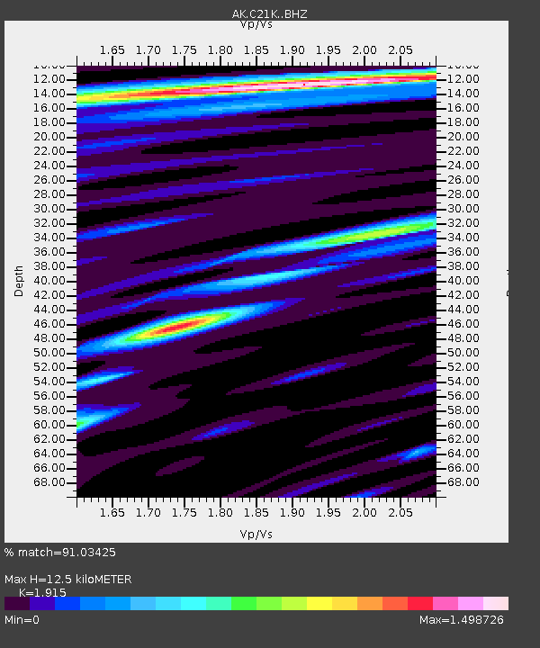
| Estimated Moho Depth: |
12.5 km |
| Estimated Crust Vp/Vs: |
1.91 |
| Assumed Crust Vp: |
6.221 km/s |
| Estimated Crust Vs: |
3.249 km/s |
| Estimated Crust Poisson's Ratio: |
0.31 |
|
| Radial Match: |
91.03425 % |
| Radial Bump: |
400 |
| Transverse Match: |
74.55529 % |
| Transverse Bump: |
400 |
| SOD ConfigId: |
30536071 |
| Insert Time: |
2023-05-31 23:03:55.192 +0000 |
| GWidth: |
2.5 |
| Max Bumps: |
400 |
| Tol: |
0.001 |
|

Signal To Noise
| Channel | StoN | STA | LTA |
| AK:C21K: :BHZ:20230517T23:11:54.059979Z | 16.965424 | 1.83885E-6 | 1.083881E-7 |
| AK:C21K: :BHN:20230517T23:11:54.059979Z | 2.197892 | 1.7397403E-7 | 7.915496E-8 |
| AK:C21K: :BHE:20230517T23:11:54.059979Z | 8.0956135 | 4.6488677E-7 | 5.7424526E-8 |
| Arrivals |
| Ps | 1.9 SECOND |
| PpPs | 5.7 SECOND |
| PsPs/PpSs | 7.6 SECOND |


