You are here: Home > Network List > AK - Alaska Regional Network Stations List
> Station E27K Coleen River, AK, USA > Earthquake Result Viewer
E27K Coleen River, AK, USA - Earthquake Result Viewer
| Earthquake location: |
Guatemala |
| Earthquake latitude/longitude: |
15.1/-90.9 |
| Earthquake time(UTC): |
2023/05/17 (137) 23:02:00 GMT |
| Earthquake Depth: |
256 km |
| Earthquake Magnitude: |
6.4 mww |
| Earthquake Catalog/Contributor: |
NEIC PDE/us |
|
| Network: |
AK Alaska Regional Network |
| Station: |
E27K Coleen River, AK, USA |
| Lat/Lon: |
68.19 N/141.60 W |
| Elevation: |
654 m |
|
| Distance: |
62.0 deg |
| Az: |
340.875 deg |
| Baz: |
122.15 deg |
| Ray Param: |
0.0596732 |
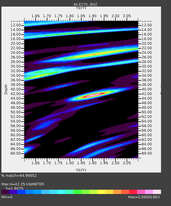
| Estimated Moho Depth: |
42.25 km |
| Estimated Crust Vp/Vs: |
1.91 |
| Assumed Crust Vp: |
6.522 km/s |
| Estimated Crust Vs: |
3.419 km/s |
| Estimated Crust Poisson's Ratio: |
0.31 |
|
| Radial Match: |
94.99852 % |
| Radial Bump: |
364 |
| Transverse Match: |
90.98627 % |
| Transverse Bump: |
387 |
| SOD ConfigId: |
30536071 |
| Insert Time: |
2023-05-31 23:04:30.900 +0000 |
| GWidth: |
2.5 |
| Max Bumps: |
400 |
| Tol: |
0.001 |
|

Signal To Noise
| Channel | StoN | STA | LTA |
| AK:E27K: :BHZ:20230517T23:11:23.400005Z | 29.668522 | 1.8485399E-6 | 6.2306434E-8 |
| AK:E27K: :BHN:20230517T23:11:23.400005Z | 4.5767236 | 3.2826807E-7 | 7.172556E-8 |
| AK:E27K: :BHE:20230517T23:11:23.400005Z | 11.409513 | 6.576592E-7 | 5.7641298E-8 |
| Arrivals |
| Ps | 6.1 SECOND |
| PpPs | 18 SECOND |
| PsPs/PpSs | 24 SECOND |


