You are here: Home > Network List > AK - Alaska Regional Network Stations List
> Station I27K Kandik River, AK, USA > Earthquake Result Viewer
I27K Kandik River, AK, USA - Earthquake Result Viewer
| Earthquake location: |
Guatemala |
| Earthquake latitude/longitude: |
15.1/-90.9 |
| Earthquake time(UTC): |
2023/05/17 (137) 23:02:00 GMT |
| Earthquake Depth: |
256 km |
| Earthquake Magnitude: |
6.4 mww |
| Earthquake Catalog/Contributor: |
NEIC PDE/us |
|
| Network: |
AK Alaska Regional Network |
| Station: |
I27K Kandik River, AK, USA |
| Lat/Lon: |
65.60 N/141.62 W |
| Elevation: |
874 m |
|
| Distance: |
60.7 deg |
| Az: |
338.35 deg |
| Baz: |
120.922 deg |
| Ray Param: |
0.060534675 |
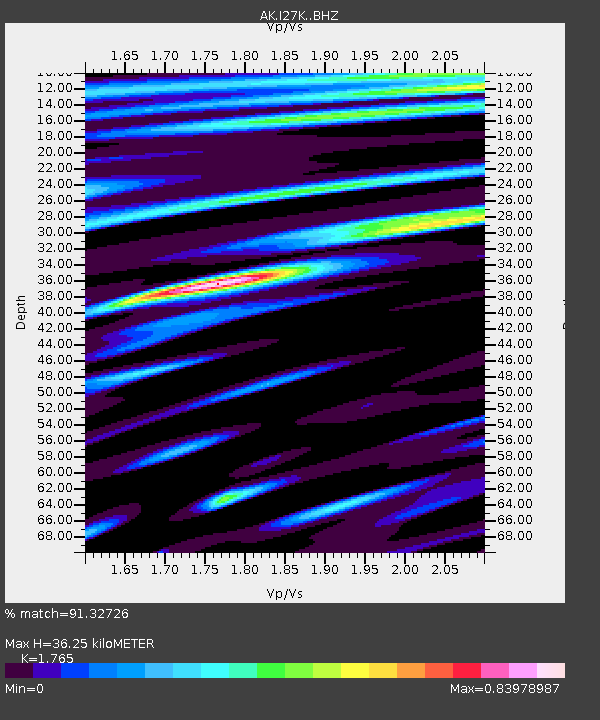
| Estimated Moho Depth: |
36.25 km |
| Estimated Crust Vp/Vs: |
1.76 |
| Assumed Crust Vp: |
6.566 km/s |
| Estimated Crust Vs: |
3.72 km/s |
| Estimated Crust Poisson's Ratio: |
0.26 |
|
| Radial Match: |
91.32726 % |
| Radial Bump: |
400 |
| Transverse Match: |
78.570724 % |
| Transverse Bump: |
400 |
| SOD ConfigId: |
30536071 |
| Insert Time: |
2023-05-31 23:05:19.842 +0000 |
| GWidth: |
2.5 |
| Max Bumps: |
400 |
| Tol: |
0.001 |
|

Signal To Noise
| Channel | StoN | STA | LTA |
| AK:I27K: :BHZ:20230517T23:11:14.400005Z | 31.385077 | 1.6114429E-6 | 5.134424E-8 |
| AK:I27K: :BHN:20230517T23:11:14.400005Z | 6.4454956 | 3.308264E-7 | 5.1326758E-8 |
| AK:I27K: :BHE:20230517T23:11:14.400005Z | 7.20517 | 5.0312826E-7 | 6.982878E-8 |
| Arrivals |
| Ps | 4.4 SECOND |
| PpPs | 15 SECOND |
| PsPs/PpSs | 19 SECOND |


