You are here: Home > Network List > AK - Alaska Regional Network Stations List
> Station TGL Tana Glacier > Earthquake Result Viewer
TGL Tana Glacier - Earthquake Result Viewer
| Earthquake location: |
Guatemala |
| Earthquake latitude/longitude: |
15.1/-90.9 |
| Earthquake time(UTC): |
2023/05/17 (137) 23:02:00 GMT |
| Earthquake Depth: |
256 km |
| Earthquake Magnitude: |
6.4 mww |
| Earthquake Catalog/Contributor: |
NEIC PDE/us |
|
| Network: |
AK Alaska Regional Network |
| Station: |
TGL Tana Glacier |
| Lat/Lon: |
60.75 N/142.83 W |
| Elevation: |
1260 m |
|
| Distance: |
58.8 deg |
| Az: |
333.115 deg |
| Baz: |
117.2 deg |
| Ray Param: |
0.06173372 |
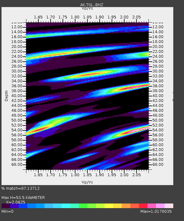
| Estimated Moho Depth: |
53.5 km |
| Estimated Crust Vp/Vs: |
2.06 |
| Assumed Crust Vp: |
6.566 km/s |
| Estimated Crust Vs: |
3.184 km/s |
| Estimated Crust Poisson's Ratio: |
0.35 |
|
| Radial Match: |
87.13712 % |
| Radial Bump: |
342 |
| Transverse Match: |
80.05239 % |
| Transverse Bump: |
400 |
| SOD ConfigId: |
30536071 |
| Insert Time: |
2023-05-31 23:07:08.012 +0000 |
| GWidth: |
2.5 |
| Max Bumps: |
400 |
| Tol: |
0.001 |
|

Signal To Noise
| Channel | StoN | STA | LTA |
| AK:TGL: :BHZ:20230517T23:11:01.627972Z | 14.415761 | 1.3406622E-6 | 9.299975E-8 |
| AK:TGL: :BHN:20230517T23:11:01.627972Z | 1.9289832 | 4.005384E-7 | 2.0764223E-7 |
| AK:TGL: :BHE:20230517T23:11:01.627972Z | 5.874445 | 4.7067908E-7 | 8.012316E-8 |
| Arrivals |
| Ps | 9.0 SECOND |
| PpPs | 24 SECOND |
| PsPs/PpSs | 33 SECOND |


