You are here: Home > Network List > AK - Alaska Regional Network Stations List
> Station V35K Ketchikan, AK, USA > Earthquake Result Viewer
V35K Ketchikan, AK, USA - Earthquake Result Viewer
| Earthquake location: |
Guatemala |
| Earthquake latitude/longitude: |
15.1/-90.9 |
| Earthquake time(UTC): |
2023/05/17 (137) 23:02:00 GMT |
| Earthquake Depth: |
256 km |
| Earthquake Magnitude: |
6.4 mww |
| Earthquake Catalog/Contributor: |
NEIC PDE/us |
|
| Network: |
AK Alaska Regional Network |
| Station: |
V35K Ketchikan, AK, USA |
| Lat/Lon: |
55.33 N/131.62 W |
| Elevation: |
64 m |
|
| Distance: |
50.9 deg |
| Az: |
331.26 deg |
| Baz: |
125.644 deg |
| Ray Param: |
0.06680086 |
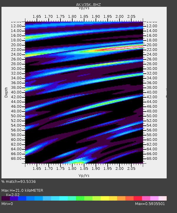
| Estimated Moho Depth: |
21.0 km |
| Estimated Crust Vp/Vs: |
2.02 |
| Assumed Crust Vp: |
6.545 km/s |
| Estimated Crust Vs: |
3.24 km/s |
| Estimated Crust Poisson's Ratio: |
0.34 |
|
| Radial Match: |
93.5336 % |
| Radial Bump: |
278 |
| Transverse Match: |
78.15059 % |
| Transverse Bump: |
400 |
| SOD ConfigId: |
30536071 |
| Insert Time: |
2023-05-31 23:07:11.476 +0000 |
| GWidth: |
2.5 |
| Max Bumps: |
400 |
| Tol: |
0.001 |
|

Signal To Noise
| Channel | StoN | STA | LTA |
| AK:V35K: :BHZ:20230517T23:10:05.259991Z | 12.14619 | 1.2576187E-6 | 1.0354018E-7 |
| AK:V35K: :BHN:20230517T23:10:05.259991Z | 3.2766001 | 4.3965144E-7 | 1.3417916E-7 |
| AK:V35K: :BHE:20230517T23:10:05.259991Z | 5.8662176 | 5.1785656E-7 | 8.8277766E-8 |
| Arrivals |
| Ps | 3.4 SECOND |
| PpPs | 9.2 SECOND |
| PsPs/PpSs | 13 SECOND |


