You are here: Home > Network List > AV - Alaska Volcano Observatory Stations List
> Station KAB2 Katmai Barrier Ridge Two, Alaska > Earthquake Result Viewer
KAB2 Katmai Barrier Ridge Two, Alaska - Earthquake Result Viewer
| Earthquake location: |
Guatemala |
| Earthquake latitude/longitude: |
15.1/-90.9 |
| Earthquake time(UTC): |
2023/05/17 (137) 23:02:00 GMT |
| Earthquake Depth: |
256 km |
| Earthquake Magnitude: |
6.4 mww |
| Earthquake Catalog/Contributor: |
NEIC PDE/us |
|
| Network: |
AV Alaska Volcano Observatory |
| Station: |
KAB2 Katmai Barrier Ridge Two, Alaska |
| Lat/Lon: |
58.13 N/154.98 W |
| Elevation: |
908 m |
|
| Distance: |
63.7 deg |
| Az: |
327.823 deg |
| Baz: |
104.195 deg |
| Ray Param: |
0.05862192 |
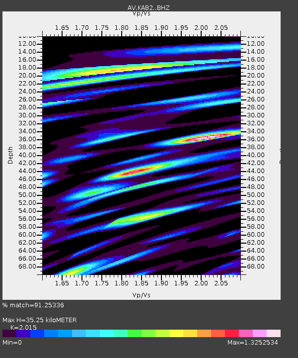
| Estimated Moho Depth: |
35.25 km |
| Estimated Crust Vp/Vs: |
2.02 |
| Assumed Crust Vp: |
6.438 km/s |
| Estimated Crust Vs: |
3.195 km/s |
| Estimated Crust Poisson's Ratio: |
0.34 |
|
| Radial Match: |
91.25336 % |
| Radial Bump: |
400 |
| Transverse Match: |
84.486465 % |
| Transverse Bump: |
400 |
| SOD ConfigId: |
30536071 |
| Insert Time: |
2023-05-31 23:08:43.297 +0000 |
| GWidth: |
2.5 |
| Max Bumps: |
400 |
| Tol: |
0.001 |
|

Signal To Noise
| Channel | StoN | STA | LTA |
| AV:KAB2: :BHZ:20230517T23:11:34.160015Z | 18.305473 | 1.4282086E-6 | 7.8020854E-8 |
| AV:KAB2: :BHN:20230517T23:11:34.160015Z | 5.783136 | 7.284462E-7 | 1.2596041E-7 |
| AV:KAB2: :BHE:20230517T23:11:34.160015Z | 6.0921946 | 7.267535E-7 | 1.1929257E-7 |
| Arrivals |
| Ps | 5.8 SECOND |
| PpPs | 16 SECOND |
| PsPs/PpSs | 22 SECOND |


