You are here: Home > Network List > AV - Alaska Volcano Observatory Stations List
> Station MAPS Pakushin Southeast, Makushin Volcano, Alaska > Earthquake Result Viewer
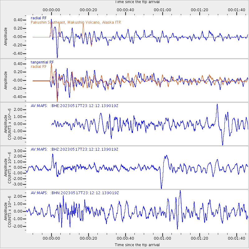
MAPS Pakushin Southeast, Makushin Volcano, Alaska - Earthquake Result Viewer
*The percent match for this event was below the threshold and hence no stack was calculated.
| Earthquake location: |
Guatemala |
| Earthquake latitude/longitude: |
15.1/-90.9 |
| Earthquake time(UTC): |
2023/05/17 (137) 23:02:00 GMT |
| Earthquake Depth: |
256 km |
| Earthquake Magnitude: |
6.4 mww |
| Earthquake Catalog/Contributor: |
NEIC PDE/us |
|
| Network: |
AV Alaska Volcano Observatory |
| Station: |
MAPS Pakushin Southeast, Makushin Volcano, Alaska |
| Lat/Lon: |
53.81 N/166.94 W |
| Elevation: |
333 m |
|
| Distance: |
69.7 deg |
| Az: |
322.144 deg |
| Baz: |
92.031 deg |
| Ray Param: |
$rayparam |
*The percent match for this event was below the threshold and hence was not used in the summary stack. |
|
| Radial Match: |
54.936275 % |
| Radial Bump: |
400 |
| Transverse Match: |
57.39205 % |
| Transverse Bump: |
400 |
| SOD ConfigId: |
30536071 |
| Insert Time: |
2023-05-31 23:09:12.311 +0000 |
| GWidth: |
2.5 |
| Max Bumps: |
400 |
| Tol: |
0.001 |
|
Signal To Noise
| Channel | StoN | STA | LTA |
| AV:MAPS: :BHZ:20230517T23:12:12.139019Z | 3.476485 | 1.0830069E-6 | 3.1152354E-7 |
| AV:MAPS: :BHN:20230517T23:12:12.139019Z | 1.7082335 | 5.8899946E-7 | 3.4480033E-7 |
| AV:MAPS: :BHE:20230517T23:12:12.139019Z | 2.1326053 | 8.741038E-7 | 4.09876E-7 |
| Arrivals |
| Ps | |
| PpPs | |
| PsPs/PpSs | |


