You are here: Home > Network List > AV - Alaska Volcano Observatory Stations List
> Station MGLS Mageik Landslide, Katmai, Volcanic Group, Alaska > Earthquake Result Viewer
MGLS Mageik Landslide, Katmai, Volcanic Group, Alaska - Earthquake Result Viewer
| Earthquake location: |
Guatemala |
| Earthquake latitude/longitude: |
15.1/-90.9 |
| Earthquake time(UTC): |
2023/05/17 (137) 23:02:00 GMT |
| Earthquake Depth: |
256 km |
| Earthquake Magnitude: |
6.4 mww |
| Earthquake Catalog/Contributor: |
NEIC PDE/us |
|
| Network: |
AV Alaska Volcano Observatory |
| Station: |
MGLS Mageik Landslide, Katmai, Volcanic Group, Alaska |
| Lat/Lon: |
58.13 N/155.16 W |
| Elevation: |
472 m |
|
| Distance: |
63.8 deg |
| Az: |
327.798 deg |
| Baz: |
104.025 deg |
| Ray Param: |
0.058560662 |
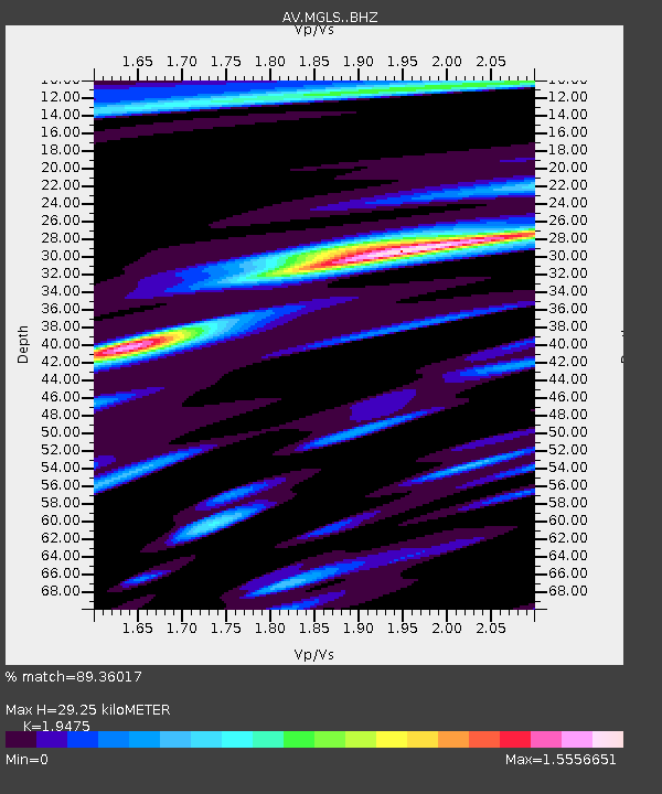
| Estimated Moho Depth: |
29.25 km |
| Estimated Crust Vp/Vs: |
1.95 |
| Assumed Crust Vp: |
6.438 km/s |
| Estimated Crust Vs: |
3.306 km/s |
| Estimated Crust Poisson's Ratio: |
0.32 |
|
| Radial Match: |
89.36017 % |
| Radial Bump: |
399 |
| Transverse Match: |
80.21368 % |
| Transverse Bump: |
400 |
| SOD ConfigId: |
30536071 |
| Insert Time: |
2023-05-31 23:09:13.413 +0000 |
| GWidth: |
2.5 |
| Max Bumps: |
400 |
| Tol: |
0.001 |
|

Signal To Noise
| Channel | StoN | STA | LTA |
| AV:MGLS: :BHZ:20230517T23:11:34.78001Z | 10.38592 | 1.4937991E-6 | 1.4382927E-7 |
| AV:MGLS: :BHN:20230517T23:11:34.78001Z | 3.092293 | 3.7937815E-7 | 1.2268505E-7 |
| AV:MGLS: :BHE:20230517T23:11:34.78001Z | 8.793476 | 8.912795E-7 | 1.013569E-7 |
| Arrivals |
| Ps | 4.5 SECOND |
| PpPs | 13 SECOND |
| PsPs/PpSs | 17 SECOND |


