You are here: Home > Network List > CC - Cascade Chain Volcano Monitoring Stations List
> Station PANH Panhandle Gap > Earthquake Result Viewer
PANH Panhandle Gap - Earthquake Result Viewer
| Earthquake location: |
Guatemala |
| Earthquake latitude/longitude: |
15.1/-90.9 |
| Earthquake time(UTC): |
2023/05/17 (137) 23:02:00 GMT |
| Earthquake Depth: |
256 km |
| Earthquake Magnitude: |
6.4 mww |
| Earthquake Catalog/Contributor: |
NEIC PDE/us |
|
| Network: |
CC Cascade Chain Volcano Monitoring |
| Station: |
PANH Panhandle Gap |
| Lat/Lon: |
46.86 N/121.64 W |
| Elevation: |
2086 m |
|
| Distance: |
40.7 deg |
| Az: |
327.421 deg |
| Baz: |
130.726 deg |
| Ray Param: |
0.07320112 |
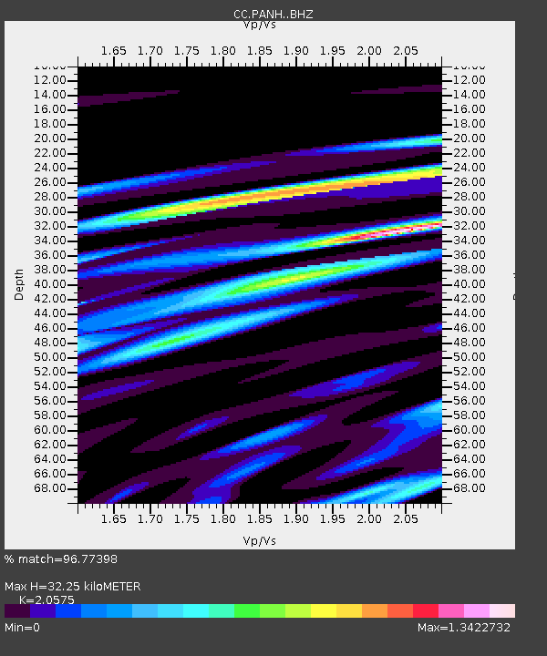
| Estimated Moho Depth: |
32.25 km |
| Estimated Crust Vp/Vs: |
2.06 |
| Assumed Crust Vp: |
6.597 km/s |
| Estimated Crust Vs: |
3.207 km/s |
| Estimated Crust Poisson's Ratio: |
0.35 |
|
| Radial Match: |
96.77398 % |
| Radial Bump: |
326 |
| Transverse Match: |
92.4245 % |
| Transverse Bump: |
400 |
| SOD ConfigId: |
30536071 |
| Insert Time: |
2023-05-31 23:13:21.924 +0000 |
| GWidth: |
2.5 |
| Max Bumps: |
400 |
| Tol: |
0.001 |
|

Signal To Noise
| Channel | StoN | STA | LTA |
| CC:PANH: :BHZ:20230517T23:08:46.199993Z | 15.484025 | 1.7377746E-6 | 1.1223016E-7 |
| CC:PANH: :BHN:20230517T23:08:46.199993Z | 9.197345 | 9.939295E-7 | 1.0806699E-7 |
| CC:PANH: :BHE:20230517T23:08:46.199993Z | 11.594159 | 1.0745707E-6 | 9.268207E-8 |
| Arrivals |
| Ps | 5.5 SECOND |
| PpPs | 14 SECOND |
| PsPs/PpSs | 20 SECOND |


