You are here: Home > Network List > CN - Canadian National Seismograph Network Stations List
> Station ULM LAC DU BONNET, MB > Earthquake Result Viewer
ULM LAC DU BONNET, MB - Earthquake Result Viewer
| Earthquake location: |
Guatemala |
| Earthquake latitude/longitude: |
15.1/-90.9 |
| Earthquake time(UTC): |
2023/05/17 (137) 23:02:00 GMT |
| Earthquake Depth: |
256 km |
| Earthquake Magnitude: |
6.4 mww |
| Earthquake Catalog/Contributor: |
NEIC PDE/us |
|
| Network: |
CN Canadian National Seismograph Network |
| Station: |
ULM LAC DU BONNET, MB |
| Lat/Lon: |
50.25 N/95.88 W |
| Elevation: |
251 m |
|
| Distance: |
35.3 deg |
| Az: |
354.417 deg |
| Baz: |
171.584 deg |
| Ray Param: |
0.07635149 |
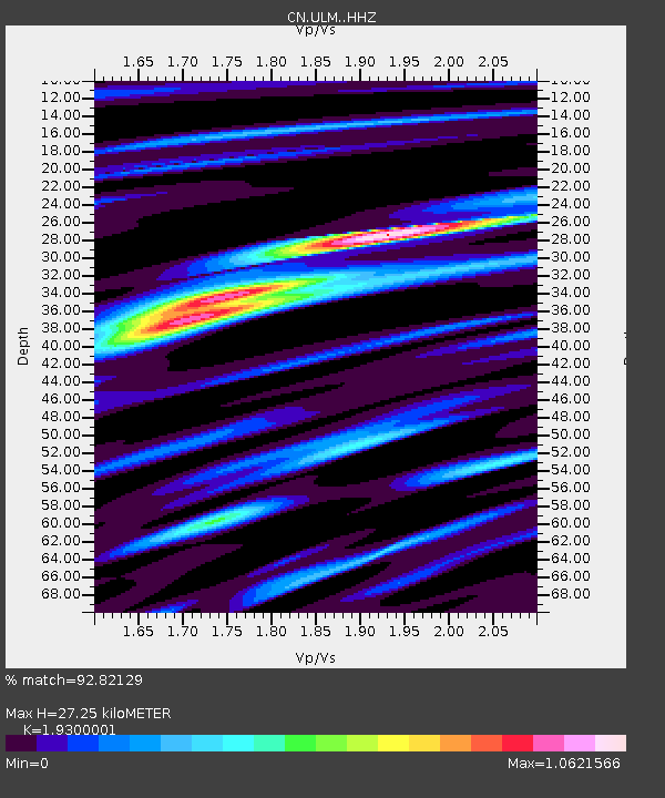
| Estimated Moho Depth: |
27.25 km |
| Estimated Crust Vp/Vs: |
1.93 |
| Assumed Crust Vp: |
6.459 km/s |
| Estimated Crust Vs: |
3.347 km/s |
| Estimated Crust Poisson's Ratio: |
0.32 |
|
| Radial Match: |
92.82129 % |
| Radial Bump: |
268 |
| Transverse Match: |
75.94566 % |
| Transverse Bump: |
351 |
| SOD ConfigId: |
30536071 |
| Insert Time: |
2023-05-31 23:18:22.241 +0000 |
| GWidth: |
2.5 |
| Max Bumps: |
400 |
| Tol: |
0.001 |
|

Signal To Noise
| Channel | StoN | STA | LTA |
| CN:ULM: :HHZ:20230517T23:08:00.970013Z | 59.82008 | 6.54713E-6 | 1.0944703E-7 |
| CN:ULM: :HHN:20230517T23:08:00.970013Z | 34.83736 | 3.6940794E-6 | 1.06037874E-7 |
| CN:ULM: :HHE:20230517T23:08:00.970013Z | 6.115029 | 6.312354E-7 | 1.0322689E-7 |
| Arrivals |
| Ps | 4.2 SECOND |
| PpPs | 12 SECOND |
| PsPs/PpSs | 16 SECOND |


