You are here: Home > Network List > GS - US Geological Survey Networks Stations List
> Station MCA04 MCA04, Monte Cristo Range, NV > Earthquake Result Viewer
MCA04 MCA04, Monte Cristo Range, NV - Earthquake Result Viewer
| Earthquake location: |
Guatemala |
| Earthquake latitude/longitude: |
15.1/-90.9 |
| Earthquake time(UTC): |
2023/05/17 (137) 23:02:00 GMT |
| Earthquake Depth: |
256 km |
| Earthquake Magnitude: |
6.4 mww |
| Earthquake Catalog/Contributor: |
NEIC PDE/us |
|
| Network: |
GS US Geological Survey Networks |
| Station: |
MCA04 MCA04, Monte Cristo Range, NV |
| Lat/Lon: |
38.08 N/117.71 W |
| Elevation: |
1662 m |
|
| Distance: |
32.9 deg |
| Az: |
319.037 deg |
| Baz: |
126.651 deg |
| Ray Param: |
0.077563435 |
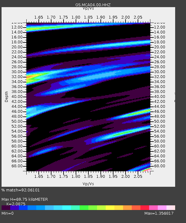
| Estimated Moho Depth: |
69.75 km |
| Estimated Crust Vp/Vs: |
2.09 |
| Assumed Crust Vp: |
6.276 km/s |
| Estimated Crust Vs: |
3.006 km/s |
| Estimated Crust Poisson's Ratio: |
0.35 |
|
| Radial Match: |
92.06101 % |
| Radial Bump: |
400 |
| Transverse Match: |
80.836426 % |
| Transverse Bump: |
400 |
| SOD ConfigId: |
30536071 |
| Insert Time: |
2023-05-31 23:20:43.694 +0000 |
| GWidth: |
2.5 |
| Max Bumps: |
400 |
| Tol: |
0.001 |
|

Signal To Noise
| Channel | StoN | STA | LTA |
| GS:MCA04:00:HHZ:20230517T23:07:41.039013Z | 10.805142 | 9.904046E-7 | 9.166049E-8 |
| GS:MCA04:00:HH1:20230517T23:07:41.039013Z | 1.7900498 | 3.425272E-7 | 1.9135064E-7 |
| GS:MCA04:00:HH2:20230517T23:07:41.039013Z | 3.9304368 | 5.309386E-7 | 1.3508388E-7 |
| Arrivals |
| Ps | 13 SECOND |
| PpPs | 32 SECOND |
| PsPs/PpSs | 45 SECOND |


