You are here: Home > Network List > MB - Montana Regional Seismic Network Stations List
> Station LIMT Lima, MT > Earthquake Result Viewer
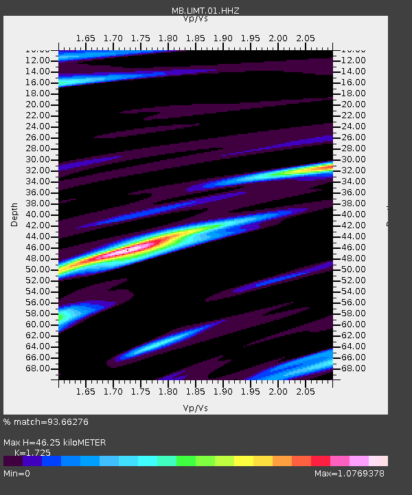
LIMT Lima, MT - Earthquake Result Viewer
| Earthquake location: |
Guatemala |
| Earthquake latitude/longitude: |
15.1/-90.9 |
| Earthquake time(UTC): |
2023/05/17 (137) 23:02:00 GMT |
| Earthquake Depth: |
256 km |
| Earthquake Magnitude: |
6.4 mww |
| Earthquake Catalog/Contributor: |
NEIC PDE/us |
|
| Network: |
MB Montana Regional Seismic Network |
| Station: |
LIMT Lima, MT |
| Lat/Lon: |
44.62 N/112.64 W |
| Elevation: |
1956 m |
|
| Distance: |
34.7 deg |
| Az: |
332.263 deg |
| Baz: |
140.993 deg |
| Ray Param: |
0.07665496 |
| Estimated Moho Depth: |
46.25 km |
| Estimated Crust Vp/Vs: |
1.73 |
| Assumed Crust Vp: |
6.577 km/s |
| Estimated Crust Vs: |
3.813 km/s |
| Estimated Crust Poisson's Ratio: |
0.25 |
|
| Radial Match: |
93.66276 % |
| Radial Bump: |
306 |
| Transverse Match: |
83.53877 % |
| Transverse Bump: |
400 |
| SOD ConfigId: |
30536071 |
| Insert Time: |
2023-05-31 23:22:47.243 +0000 |
| GWidth: |
2.5 |
| Max Bumps: |
400 |
| Tol: |
0.001 |
|

Signal To Noise
| Channel | StoN | STA | LTA |
| MB:LIMT:01:HHZ:20230517T23:07:56.28001Z | 17.931522 | 3.9330207E-6 | 2.1933556E-7 |
| MB:LIMT:01:HHN:20230517T23:07:56.28001Z | 4.497889 | 1.3490212E-6 | 2.999232E-7 |
| MB:LIMT:01:HHE:20230517T23:07:56.28001Z | 6.195879 | 1.2295168E-6 | 1.9844107E-7 |
| Arrivals |
| Ps | 5.5 SECOND |
| PpPs | 18 SECOND |
| PsPs/PpSs | 23 SECOND |


