You are here: Home > Network List > N4 - Central and EAstern US Network Stations List
> Station SUSD Miller, SD, USA > Earthquake Result Viewer
SUSD Miller, SD, USA - Earthquake Result Viewer
| Earthquake location: |
Guatemala |
| Earthquake latitude/longitude: |
15.1/-90.9 |
| Earthquake time(UTC): |
2023/05/17 (137) 23:02:00 GMT |
| Earthquake Depth: |
256 km |
| Earthquake Magnitude: |
6.4 mww |
| Earthquake Catalog/Contributor: |
NEIC PDE/us |
|
| Network: |
N4 Central and EAstern US Network |
| Station: |
SUSD Miller, SD, USA |
| Lat/Lon: |
44.44 N/98.96 W |
| Elevation: |
520 m |
|
| Distance: |
30.0 deg |
| Az: |
348.362 deg |
| Baz: |
164.217 deg |
| Ray Param: |
0.07887932 |
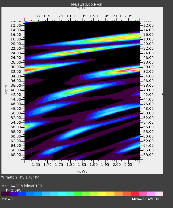
| Estimated Moho Depth: |
30.5 km |
| Estimated Crust Vp/Vs: |
2.10 |
| Assumed Crust Vp: |
6.53 km/s |
| Estimated Crust Vs: |
3.117 km/s |
| Estimated Crust Poisson's Ratio: |
0.35 |
|
| Radial Match: |
93.170494 % |
| Radial Bump: |
378 |
| Transverse Match: |
81.179886 % |
| Transverse Bump: |
400 |
| SOD ConfigId: |
30536071 |
| Insert Time: |
2023-05-31 23:23:36.244 +0000 |
| GWidth: |
2.5 |
| Max Bumps: |
400 |
| Tol: |
0.001 |
|

Signal To Noise
| Channel | StoN | STA | LTA |
| N4:SUSD:00:HHZ:20230517T23:07:15.699993Z | 29.58558 | 4.297923E-6 | 1.4527086E-7 |
| N4:SUSD:00:HH1:20230517T23:07:15.699993Z | 20.749086 | 3.5687965E-6 | 1.7199777E-7 |
| N4:SUSD:00:HH2:20230517T23:07:15.699993Z | 4.3237343 | 9.438248E-7 | 2.1828926E-7 |
| Arrivals |
| Ps | 5.5 SECOND |
| PpPs | 13 SECOND |
| PsPs/PpSs | 19 SECOND |


