You are here: Home > Network List > UU - University of Utah Regional Network Stations List
> Station FORU South Mineral Mountains, UT, USA > Earthquake Result Viewer
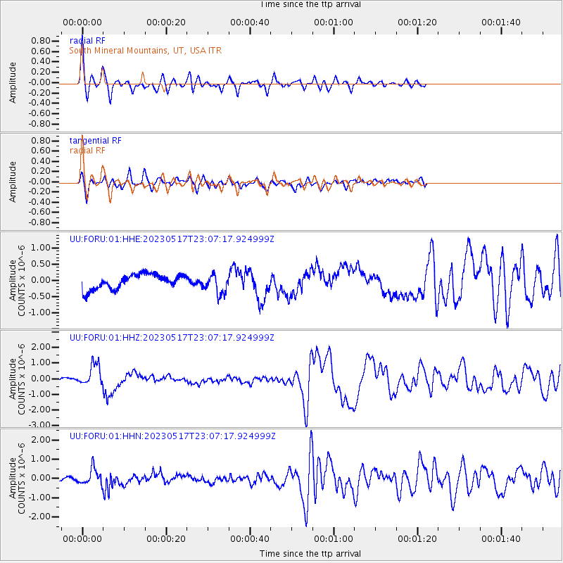
FORU South Mineral Mountains, UT, USA - Earthquake Result Viewer
*The percent match for this event was below the threshold and hence no stack was calculated.
| Earthquake location: |
Guatemala |
| Earthquake latitude/longitude: |
15.1/-90.9 |
| Earthquake time(UTC): |
2023/05/17 (137) 23:02:00 GMT |
| Earthquake Depth: |
256 km |
| Earthquake Magnitude: |
6.4 mww |
| Earthquake Catalog/Contributor: |
NEIC PDE/us |
|
| Network: |
UU University of Utah Regional Network |
| Station: |
FORU South Mineral Mountains, UT, USA |
| Lat/Lon: |
38.46 N/112.86 W |
| Elevation: |
1840 m |
|
| Distance: |
30.3 deg |
| Az: |
324.308 deg |
| Baz: |
134.132 deg |
| Ray Param: |
$rayparam |
*The percent match for this event was below the threshold and hence was not used in the summary stack. |
|
| Radial Match: |
75.88665 % |
| Radial Bump: |
400 |
| Transverse Match: |
69.40632 % |
| Transverse Bump: |
400 |
| SOD ConfigId: |
30536071 |
| Insert Time: |
2023-05-31 23:30:00.098 +0000 |
| GWidth: |
2.5 |
| Max Bumps: |
400 |
| Tol: |
0.001 |
|
Signal To Noise
| Channel | StoN | STA | LTA |
| UU:FORU:01:HHZ:20230517T23:07:17.924999Z | 4.6044035 | 7.144656E-7 | 1.5517007E-7 |
| UU:FORU:01:HHN:20230517T23:07:17.924999Z | 2.5746806 | 4.1090206E-7 | 1.595934E-7 |
| UU:FORU:01:HHE:20230517T23:07:17.924999Z | 1.3451035 | 3.078869E-7 | 2.2889458E-7 |
| Arrivals |
| Ps | |
| PpPs | |
| PsPs/PpSs | |


