You are here: Home > Network List > UU - University of Utah Regional Network Stations List
> Station TMU Trail Mountain (BB), UT, USA > Earthquake Result Viewer
TMU Trail Mountain (BB), UT, USA - Earthquake Result Viewer
| Earthquake location: |
Guatemala |
| Earthquake latitude/longitude: |
15.1/-90.9 |
| Earthquake time(UTC): |
2023/05/17 (137) 23:02:00 GMT |
| Earthquake Depth: |
256 km |
| Earthquake Magnitude: |
6.4 mww |
| Earthquake Catalog/Contributor: |
NEIC PDE/us |
|
| Network: |
UU University of Utah Regional Network |
| Station: |
TMU Trail Mountain (BB), UT, USA |
| Lat/Lon: |
39.30 N/111.21 W |
| Elevation: |
2731 m |
|
| Distance: |
30.0 deg |
| Az: |
327.314 deg |
| Baz: |
137.766 deg |
| Ray Param: |
0.07889611 |
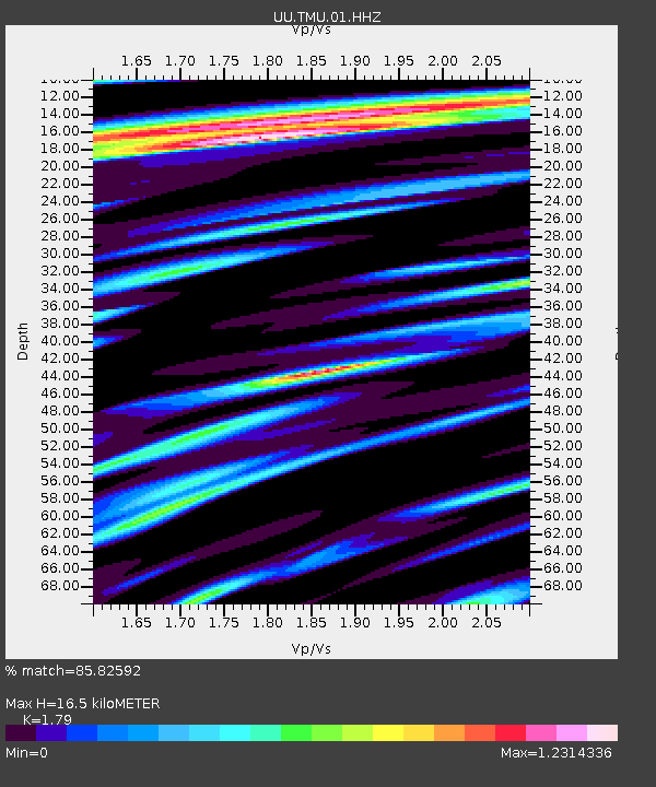
| Estimated Moho Depth: |
16.5 km |
| Estimated Crust Vp/Vs: |
1.79 |
| Assumed Crust Vp: |
6.207 km/s |
| Estimated Crust Vs: |
3.467 km/s |
| Estimated Crust Poisson's Ratio: |
0.27 |
|
| Radial Match: |
85.82592 % |
| Radial Bump: |
400 |
| Transverse Match: |
83.453735 % |
| Transverse Bump: |
400 |
| SOD ConfigId: |
30536071 |
| Insert Time: |
2023-05-31 23:30:18.901 +0000 |
| GWidth: |
2.5 |
| Max Bumps: |
400 |
| Tol: |
0.001 |
|

Signal To Noise
| Channel | StoN | STA | LTA |
| UU:TMU:01:HHZ:20230517T23:07:15.329998Z | 6.3472867 | 1.2450112E-6 | 1.9614856E-7 |
| UU:TMU:01:HHN:20230517T23:07:15.329998Z | 2.461795 | 6.257973E-7 | 2.5420366E-7 |
| UU:TMU:01:HHE:20230517T23:07:15.329998Z | 4.2121706 | 6.409457E-7 | 1.5216519E-7 |
| Arrivals |
| Ps | 2.3 SECOND |
| PpPs | 6.9 SECOND |
| PsPs/PpSs | 9.2 SECOND |


