You are here: Home > Network List > UW - Pacific Northwest Regional Seismic Network Stations List
> Station DATON Dayton, WA, USA > Earthquake Result Viewer
DATON Dayton, WA, USA - Earthquake Result Viewer
| Earthquake location: |
Guatemala |
| Earthquake latitude/longitude: |
15.1/-90.9 |
| Earthquake time(UTC): |
2023/05/17 (137) 23:02:00 GMT |
| Earthquake Depth: |
256 km |
| Earthquake Magnitude: |
6.4 mww |
| Earthquake Catalog/Contributor: |
NEIC PDE/us |
|
| Network: |
UW Pacific Northwest Regional Seismic Network |
| Station: |
DATON Dayton, WA, USA |
| Lat/Lon: |
46.26 N/117.93 W |
| Elevation: |
815 m |
|
| Distance: |
38.4 deg |
| Az: |
329.473 deg |
| Baz: |
134.999 deg |
| Ray Param: |
0.07454857 |
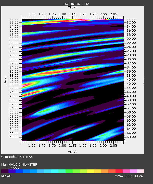
| Estimated Moho Depth: |
10.0 km |
| Estimated Crust Vp/Vs: |
2.01 |
| Assumed Crust Vp: |
6.571 km/s |
| Estimated Crust Vs: |
3.277 km/s |
| Estimated Crust Poisson's Ratio: |
0.33 |
|
| Radial Match: |
86.13154 % |
| Radial Bump: |
400 |
| Transverse Match: |
77.8408 % |
| Transverse Bump: |
400 |
| SOD ConfigId: |
30536071 |
| Insert Time: |
2023-05-31 23:31:00.255 +0000 |
| GWidth: |
2.5 |
| Max Bumps: |
400 |
| Tol: |
0.001 |
|

Signal To Noise
| Channel | StoN | STA | LTA |
| UW:DATON: :HHZ:20230517T23:08:27.449993Z | 16.299852 | 1.6261131E-6 | 9.9762445E-8 |
| UW:DATON: :HHN:20230517T23:08:27.449993Z | 5.2816496 | 5.225826E-7 | 9.894306E-8 |
| UW:DATON: :HHE:20230517T23:08:27.449993Z | 5.9350195 | 4.8094023E-7 | 8.1034315E-8 |
| Arrivals |
| Ps | 1.6 SECOND |
| PpPs | 4.3 SECOND |
| PsPs/PpSs | 5.9 SECOND |


