You are here: Home > Network List > UW - Pacific Northwest Regional Seismic Network Stations List
> Station HOQUI City of Hoquiam Watershed, Hoquiam, WA, USA > Earthquake Result Viewer
HOQUI City of Hoquiam Watershed, Hoquiam, WA, USA - Earthquake Result Viewer
| Earthquake location: |
Guatemala |
| Earthquake latitude/longitude: |
15.1/-90.9 |
| Earthquake time(UTC): |
2023/05/17 (137) 23:02:00 GMT |
| Earthquake Depth: |
256 km |
| Earthquake Magnitude: |
6.4 mww |
| Earthquake Catalog/Contributor: |
NEIC PDE/us |
|
| Network: |
UW Pacific Northwest Regional Seismic Network |
| Station: |
HOQUI City of Hoquiam Watershed, Hoquiam, WA, USA |
| Lat/Lon: |
47.08 N/123.96 W |
| Elevation: |
101 m |
|
| Distance: |
42.1 deg |
| Az: |
326.159 deg |
| Baz: |
128.093 deg |
| Ray Param: |
0.07235737 |
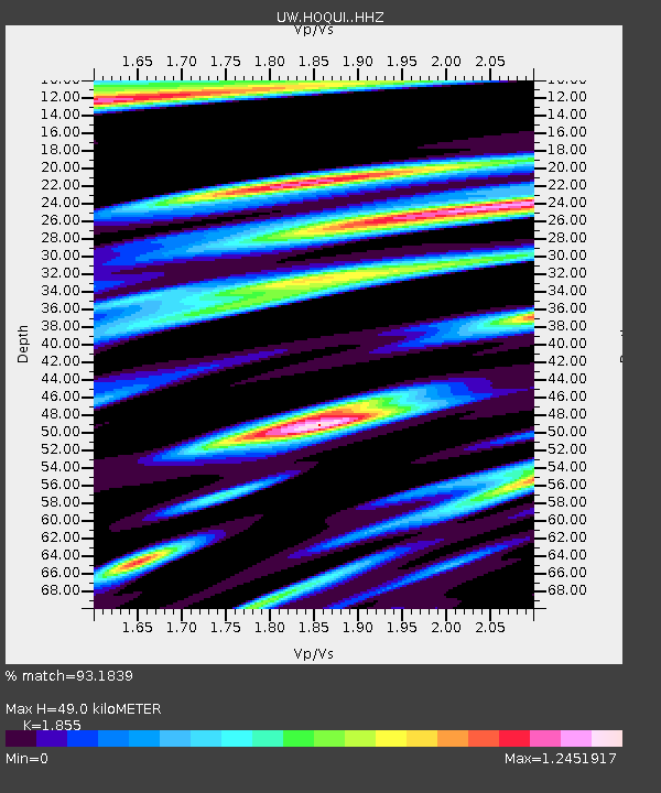
| Estimated Moho Depth: |
49.0 km |
| Estimated Crust Vp/Vs: |
1.86 |
| Assumed Crust Vp: |
6.566 km/s |
| Estimated Crust Vs: |
3.54 km/s |
| Estimated Crust Poisson's Ratio: |
0.30 |
|
| Radial Match: |
93.1839 % |
| Radial Bump: |
400 |
| Transverse Match: |
84.31892 % |
| Transverse Bump: |
400 |
| SOD ConfigId: |
30536071 |
| Insert Time: |
2023-05-31 23:31:45.714 +0000 |
| GWidth: |
2.5 |
| Max Bumps: |
400 |
| Tol: |
0.001 |
|

Signal To Noise
| Channel | StoN | STA | LTA |
| UW:HOQUI: :HHZ:20230517T23:08:57.229992Z | 13.503879 | 2.7283056E-6 | 2.0203866E-7 |
| UW:HOQUI: :HHN:20230517T23:08:57.229992Z | 5.5745187 | 1.5925756E-6 | 2.8568843E-7 |
| UW:HOQUI: :HHE:20230517T23:08:57.229992Z | 3.4307814 | 1.1670186E-6 | 3.4016117E-7 |
| Arrivals |
| Ps | 6.8 SECOND |
| PpPs | 20 SECOND |
| PsPs/PpSs | 27 SECOND |


