You are here: Home > Network List > UW - Pacific Northwest Regional Seismic Network Stations List
> Station LEID Weyerhaeuser Tree Farm, Grays Harbor County, WA, USA > Earthquake Result Viewer
LEID Weyerhaeuser Tree Farm, Grays Harbor County, WA, USA - Earthquake Result Viewer
| Earthquake location: |
Guatemala |
| Earthquake latitude/longitude: |
15.1/-90.9 |
| Earthquake time(UTC): |
2023/05/17 (137) 23:02:00 GMT |
| Earthquake Depth: |
256 km |
| Earthquake Magnitude: |
6.4 mww |
| Earthquake Catalog/Contributor: |
NEIC PDE/us |
|
| Network: |
UW Pacific Northwest Regional Seismic Network |
| Station: |
LEID Weyerhaeuser Tree Farm, Grays Harbor County, WA, USA |
| Lat/Lon: |
46.83 N/123.47 W |
| Elevation: |
535 m |
|
| Distance: |
41.7 deg |
| Az: |
326.175 deg |
| Baz: |
128.463 deg |
| Ray Param: |
0.07262346 |
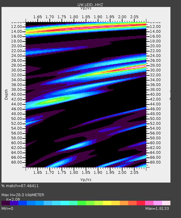
| Estimated Moho Depth: |
28.0 km |
| Estimated Crust Vp/Vs: |
2.09 |
| Assumed Crust Vp: |
6.566 km/s |
| Estimated Crust Vs: |
3.142 km/s |
| Estimated Crust Poisson's Ratio: |
0.35 |
|
| Radial Match: |
87.46411 % |
| Radial Bump: |
400 |
| Transverse Match: |
80.09174 % |
| Transverse Bump: |
400 |
| SOD ConfigId: |
30536071 |
| Insert Time: |
2023-05-31 23:32:09.690 +0000 |
| GWidth: |
2.5 |
| Max Bumps: |
400 |
| Tol: |
0.001 |
|

Signal To Noise
| Channel | StoN | STA | LTA |
| UW:LEID: :HHZ:20230517T23:08:53.849987Z | 17.137358 | 1.796371E-6 | 1.0482192E-7 |
| UW:LEID: :HHN:20230517T23:08:53.849987Z | 3.3241334 | 7.570478E-7 | 2.2774292E-7 |
| UW:LEID: :HHE:20230517T23:08:53.849987Z | 3.2437081 | 6.238819E-7 | 1.92336E-7 |
| Arrivals |
| Ps | 4.9 SECOND |
| PpPs | 12 SECOND |
| PsPs/PpSs | 17 SECOND |


