You are here: Home > Network List > 1E - GSC-BCOGC Induced Seismicity Study Stations List
> Station MONT7 Z > Earthquake Result Viewer
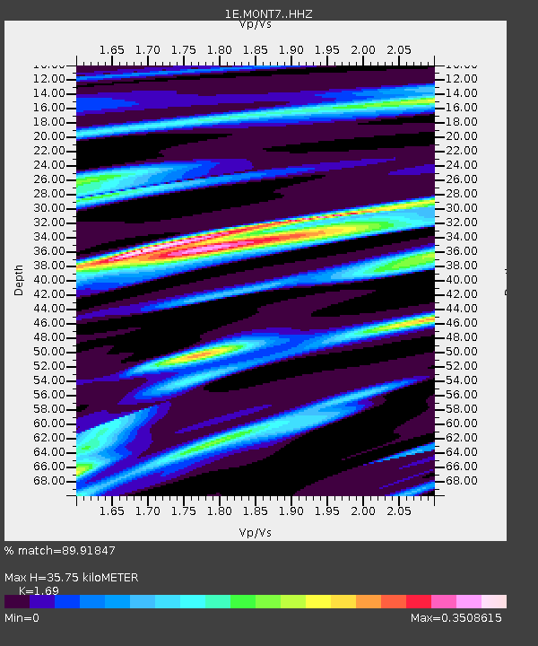
MONT7 Z - Earthquake Result Viewer
| Earthquake location: |
Southeast Of Loyalty Islands |
| Earthquake latitude/longitude: |
-23.2/170.7 |
| Earthquake time(UTC): |
2023/05/19 (139) 02:57:07 GMT |
| Earthquake Depth: |
10 km |
| Earthquake Magnitude: |
7.7 Mi |
| Earthquake Catalog/Contributor: |
NEIC PDE/at |
|
| Network: |
1E GSC-BCOGC Induced Seismicity Study |
| Station: |
MONT7 Z |
| Lat/Lon: |
56.31 N/122.03 W |
| Elevation: |
797 m |
|
| Distance: |
97.3 deg |
| Az: |
31.227 deg |
| Baz: |
238.863 deg |
| Ray Param: |
0.040254332 |
| Estimated Moho Depth: |
35.75 km |
| Estimated Crust Vp/Vs: |
1.69 |
| Assumed Crust Vp: |
6.232 km/s |
| Estimated Crust Vs: |
3.687 km/s |
| Estimated Crust Poisson's Ratio: |
0.23 |
|
| Radial Match: |
89.91847 % |
| Radial Bump: |
306 |
| Transverse Match: |
57.15193 % |
| Transverse Bump: |
400 |
| SOD ConfigId: |
30536071 |
| Insert Time: |
2023-06-02 02:58:46.945 +0000 |
| GWidth: |
2.5 |
| Max Bumps: |
400 |
| Tol: |
0.001 |
|

Signal To Noise
| Channel | StoN | STA | LTA |
| 1E:MONT7: :HHZ:20230519T03:10:08.440002Z | 17.813702 | 3.330857E-6 | 1.8698287E-7 |
| 1E:MONT7: :HHN:20230519T03:10:08.440002Z | 1.0240045 | 6.609132E-7 | 6.454203E-7 |
| 1E:MONT7: :HHE:20230519T03:10:08.440002Z | 2.1094117 | 5.986205E-7 | 2.8378554E-7 |
| Arrivals |
| Ps | 4.0 SECOND |
| PpPs | 15 SECOND |
| PsPs/PpSs | 19 SECOND |


