You are here: Home > Network List > US - United States National Seismic Network Stations List
> Station HAWA Hanford, Washington, USA > Earthquake Result Viewer
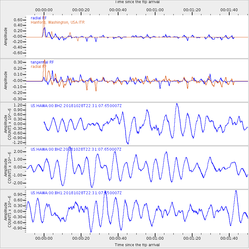
HAWA Hanford, Washington, USA - Earthquake Result Viewer
*The percent match for this event was below the threshold and hence no stack was calculated.
| Earthquake location: |
Off Coast Of Central America |
| Earthquake latitude/longitude: |
12.9/-90.4 |
| Earthquake time(UTC): |
2018/10/28 (301) 22:23:54 GMT |
| Earthquake Depth: |
25 km |
| Earthquake Magnitude: |
6.1 Mww |
| Earthquake Catalog/Contributor: |
NEIC PDE/us |
|
| Network: |
US United States National Seismic Network |
| Station: |
HAWA Hanford, Washington, USA |
| Lat/Lon: |
46.39 N/119.53 W |
| Elevation: |
364 m |
|
| Distance: |
41.4 deg |
| Az: |
329.357 deg |
| Baz: |
134.117 deg |
| Ray Param: |
$rayparam |
*The percent match for this event was below the threshold and hence was not used in the summary stack. |
|
| Radial Match: |
65.24607 % |
| Radial Bump: |
400 |
| Transverse Match: |
62.46094 % |
| Transverse Bump: |
400 |
| SOD ConfigId: |
3103472 |
| Insert Time: |
2018-11-11 22:34:41.075 +0000 |
| GWidth: |
2.5 |
| Max Bumps: |
400 |
| Tol: |
0.001 |
|
Signal To Noise
| Channel | StoN | STA | LTA |
| US:HAWA:00:BHZ:20181028T22:31:07.650007Z | 2.4585986 | 8.4625054E-7 | 3.4420037E-7 |
| US:HAWA:00:BH1:20181028T22:31:07.650007Z | 1.0134609 | 3.311042E-7 | 3.2670644E-7 |
| US:HAWA:00:BH2:20181028T22:31:07.650007Z | 0.71475077 | 1.8527776E-7 | 2.592201E-7 |
| Arrivals |
| Ps | |
| PpPs | |
| PsPs/PpSs | |


