You are here: Home > Network List > AK - Alaska Regional Network Stations List
> Station FALS False Pass > Earthquake Result Viewer
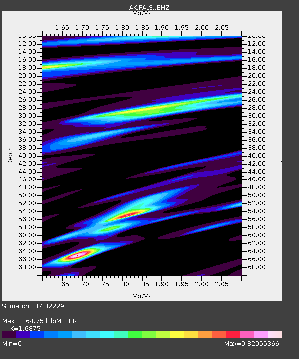
FALS False Pass - Earthquake Result Viewer
| Earthquake location: |
Southeast Of Loyalty Islands |
| Earthquake latitude/longitude: |
-23.2/170.7 |
| Earthquake time(UTC): |
2023/05/19 (139) 02:57:07 GMT |
| Earthquake Depth: |
10 km |
| Earthquake Magnitude: |
7.7 Mi |
| Earthquake Catalog/Contributor: |
NEIC PDE/at |
|
| Network: |
AK Alaska Regional Network |
| Station: |
FALS False Pass |
| Lat/Lon: |
54.86 N/163.42 W |
| Elevation: |
46 m |
|
| Distance: |
80.9 deg |
| Az: |
14.839 deg |
| Baz: |
204.052 deg |
| Ray Param: |
0.04799527 |
| Estimated Moho Depth: |
64.75 km |
| Estimated Crust Vp/Vs: |
1.69 |
| Assumed Crust Vp: |
5.989 km/s |
| Estimated Crust Vs: |
3.549 km/s |
| Estimated Crust Poisson's Ratio: |
0.23 |
|
| Radial Match: |
87.82229 % |
| Radial Bump: |
400 |
| Transverse Match: |
71.41789 % |
| Transverse Bump: |
400 |
| SOD ConfigId: |
30536071 |
| Insert Time: |
2023-06-02 03:00:32.619 +0000 |
| GWidth: |
2.5 |
| Max Bumps: |
400 |
| Tol: |
0.001 |
|

Signal To Noise
| Channel | StoN | STA | LTA |
| AK:FALS: :BHZ:20230519T03:08:49.588013Z | 22.173122 | 1.4583392E-5 | 6.5770587E-7 |
| AK:FALS: :BHN:20230519T03:08:49.588013Z | 4.591211 | 5.6207728E-6 | 1.2242463E-6 |
| AK:FALS: :BHE:20230519T03:08:49.588013Z | 2.184424 | 2.2186248E-6 | 1.0156567E-6 |
| Arrivals |
| Ps | 7.6 SECOND |
| PpPs | 28 SECOND |
| PsPs/PpSs | 36 SECOND |


