You are here: Home > Network List > UU - University of Utah Regional Network Stations List
> Station CCUT Cedar City, UT, USA > Earthquake Result Viewer
CCUT Cedar City, UT, USA - Earthquake Result Viewer
| Earthquake location: |
Off Coast Of Central America |
| Earthquake latitude/longitude: |
12.9/-90.4 |
| Earthquake time(UTC): |
2018/10/28 (301) 22:23:54 GMT |
| Earthquake Depth: |
25 km |
| Earthquake Magnitude: |
6.1 Mww |
| Earthquake Catalog/Contributor: |
NEIC PDE/us |
|
| Network: |
UU University of Utah Regional Network |
| Station: |
CCUT Cedar City, UT, USA |
| Lat/Lon: |
37.55 N/113.36 W |
| Elevation: |
2127 m |
|
| Distance: |
32.0 deg |
| Az: |
324.107 deg |
| Baz: |
134.018 deg |
| Ray Param: |
0.07882752 |
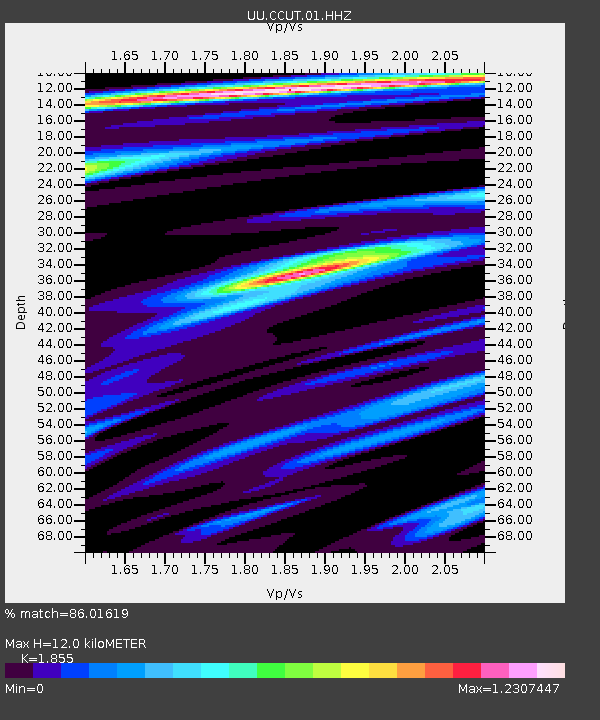
| Estimated Moho Depth: |
12.0 km |
| Estimated Crust Vp/Vs: |
1.86 |
| Assumed Crust Vp: |
6.194 km/s |
| Estimated Crust Vs: |
3.339 km/s |
| Estimated Crust Poisson's Ratio: |
0.30 |
|
| Radial Match: |
86.01619 % |
| Radial Bump: |
400 |
| Transverse Match: |
73.38745 % |
| Transverse Bump: |
400 |
| SOD ConfigId: |
3103472 |
| Insert Time: |
2018-11-11 22:35:02.574 +0000 |
| GWidth: |
2.5 |
| Max Bumps: |
400 |
| Tol: |
0.001 |
|

Signal To Noise
| Channel | StoN | STA | LTA |
| UU:CCUT:01:HHZ:20181028T22:29:47.335005Z | 10.304264 | 1.0181785E-6 | 9.881137E-8 |
| UU:CCUT:01:HHN:20181028T22:29:47.335005Z | 2.6913748 | 5.2961605E-7 | 1.9678271E-7 |
| UU:CCUT:01:HHE:20181028T22:29:47.335005Z | 2.3072207 | 5.5670955E-7 | 2.412901E-7 |
| Arrivals |
| Ps | 1.8 SECOND |
| PpPs | 5.2 SECOND |
| PsPs/PpSs | 6.9 SECOND |


