You are here: Home > Network List > AV - Alaska Volcano Observatory Stations List
> Station KARR Katmai Rainbow River, Alaska > Earthquake Result Viewer
KARR Katmai Rainbow River, Alaska - Earthquake Result Viewer
| Earthquake location: |
Southeast Of Loyalty Islands |
| Earthquake latitude/longitude: |
-23.2/170.7 |
| Earthquake time(UTC): |
2023/05/19 (139) 02:57:07 GMT |
| Earthquake Depth: |
10 km |
| Earthquake Magnitude: |
7.7 Mi |
| Earthquake Catalog/Contributor: |
NEIC PDE/at |
|
| Network: |
AV Alaska Volcano Observatory |
| Station: |
KARR Katmai Rainbow River, Alaska |
| Lat/Lon: |
58.50 N/154.71 W |
| Elevation: |
610 m |
|
| Distance: |
86.3 deg |
| Az: |
17.404 deg |
| Baz: |
211.61 deg |
| Ray Param: |
0.04414081 |
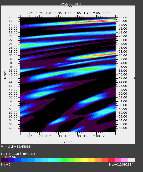
| Estimated Moho Depth: |
11.5 km |
| Estimated Crust Vp/Vs: |
2.09 |
| Assumed Crust Vp: |
6.438 km/s |
| Estimated Crust Vs: |
3.08 km/s |
| Estimated Crust Poisson's Ratio: |
0.35 |
|
| Radial Match: |
85.65888 % |
| Radial Bump: |
400 |
| Transverse Match: |
80.51383 % |
| Transverse Bump: |
400 |
| SOD ConfigId: |
30536071 |
| Insert Time: |
2023-06-02 03:06:09.484 +0000 |
| GWidth: |
2.5 |
| Max Bumps: |
400 |
| Tol: |
0.001 |
|

Signal To Noise
| Channel | StoN | STA | LTA |
| AV:KARR: :BHZ:20230519T03:09:17.52002Z | 65.16856 | 1.5876385E-5 | 2.4362032E-7 |
| AV:KARR: :BHN:20230519T03:09:17.52002Z | 20.47189 | 5.1612296E-6 | 2.52113E-7 |
| AV:KARR: :BHE:20230519T03:09:17.52002Z | 15.035077 | 3.9075635E-6 | 2.5989647E-7 |
| Arrivals |
| Ps | 2.0 SECOND |
| PpPs | 5.4 SECOND |
| PsPs/PpSs | 7.4 SECOND |


