You are here: Home > Network List > AV - Alaska Volcano Observatory Stations List
> Station KIMD MID Benchmark, Kanaga Volcano, Alaska > Earthquake Result Viewer
KIMD MID Benchmark, Kanaga Volcano, Alaska - Earthquake Result Viewer
| Earthquake location: |
Southeast Of Loyalty Islands |
| Earthquake latitude/longitude: |
-23.2/170.7 |
| Earthquake time(UTC): |
2023/05/19 (139) 02:57:07 GMT |
| Earthquake Depth: |
10 km |
| Earthquake Magnitude: |
7.7 Mi |
| Earthquake Catalog/Contributor: |
NEIC PDE/at |
|
| Network: |
AV Alaska Volcano Observatory |
| Station: |
KIMD MID Benchmark, Kanaga Volcano, Alaska |
| Lat/Lon: |
51.76 N/177.24 W |
| Elevation: |
183 m |
|
| Distance: |
75.4 deg |
| Az: |
7.745 deg |
| Baz: |
191.508 deg |
| Ray Param: |
0.051712383 |
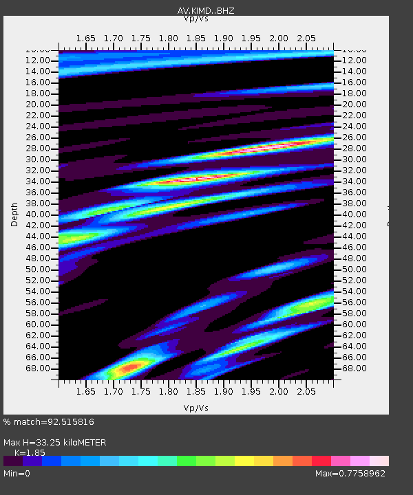
| Estimated Moho Depth: |
33.25 km |
| Estimated Crust Vp/Vs: |
1.85 |
| Assumed Crust Vp: |
5.88 km/s |
| Estimated Crust Vs: |
3.179 km/s |
| Estimated Crust Poisson's Ratio: |
0.29 |
|
| Radial Match: |
92.515816 % |
| Radial Bump: |
400 |
| Transverse Match: |
90.069405 % |
| Transverse Bump: |
400 |
| SOD ConfigId: |
30536071 |
| Insert Time: |
2023-06-02 03:06:20.962 +0000 |
| GWidth: |
2.5 |
| Max Bumps: |
400 |
| Tol: |
0.001 |
|

Signal To Noise
| Channel | StoN | STA | LTA |
| AV:KIMD: :BHZ:20230519T03:08:19.359009Z | 47.33722 | 2.1299134E-5 | 4.4994476E-7 |
| AV:KIMD: :BHN:20230519T03:08:19.359009Z | 23.498993 | 7.761801E-6 | 3.3030355E-7 |
| AV:KIMD: :BHE:20230519T03:08:19.359009Z | 4.3654475 | 1.3799196E-6 | 3.1610037E-7 |
| Arrivals |
| Ps | 4.9 SECOND |
| PpPs | 16 SECOND |
| PsPs/PpSs | 21 SECOND |


