You are here: Home > Network List > AV - Alaska Volcano Observatory Stations List
> Station KJL Kejulik, Katmai, Alaska > Earthquake Result Viewer
KJL Kejulik, Katmai, Alaska - Earthquake Result Viewer
| Earthquake location: |
Southeast Of Loyalty Islands |
| Earthquake latitude/longitude: |
-23.2/170.7 |
| Earthquake time(UTC): |
2023/05/19 (139) 02:57:07 GMT |
| Earthquake Depth: |
10 km |
| Earthquake Magnitude: |
7.7 Mi |
| Earthquake Catalog/Contributor: |
NEIC PDE/at |
|
| Network: |
AV Alaska Volcano Observatory |
| Station: |
KJL Kejulik, Katmai, Alaska |
| Lat/Lon: |
58.05 N/155.58 W |
| Elevation: |
792 m |
|
| Distance: |
85.7 deg |
| Az: |
17.242 deg |
| Baz: |
210.861 deg |
| Ray Param: |
0.044579115 |
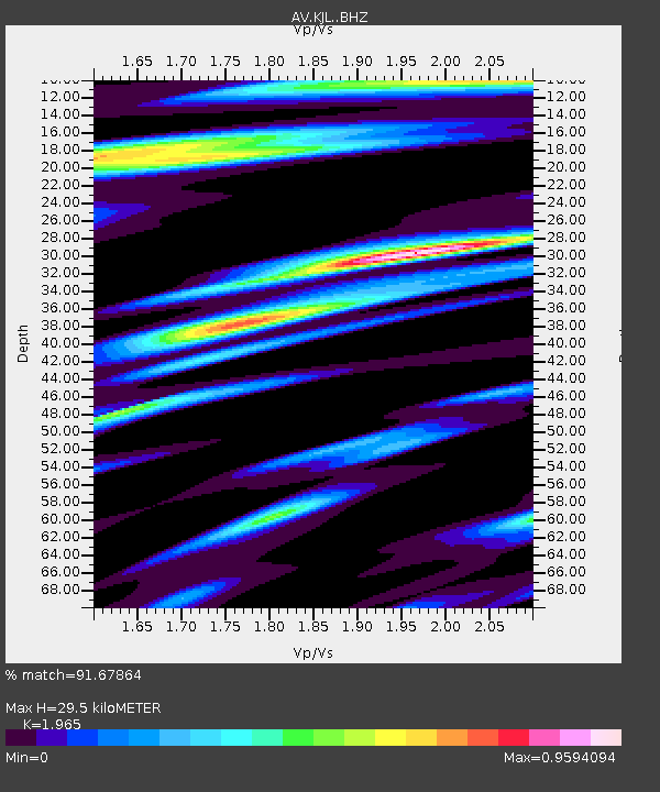
| Estimated Moho Depth: |
29.5 km |
| Estimated Crust Vp/Vs: |
1.97 |
| Assumed Crust Vp: |
6.438 km/s |
| Estimated Crust Vs: |
3.276 km/s |
| Estimated Crust Poisson's Ratio: |
0.33 |
|
| Radial Match: |
91.67864 % |
| Radial Bump: |
400 |
| Transverse Match: |
84.696945 % |
| Transverse Bump: |
400 |
| SOD ConfigId: |
30536071 |
| Insert Time: |
2023-06-02 03:06:27.410 +0000 |
| GWidth: |
2.5 |
| Max Bumps: |
400 |
| Tol: |
0.001 |
|
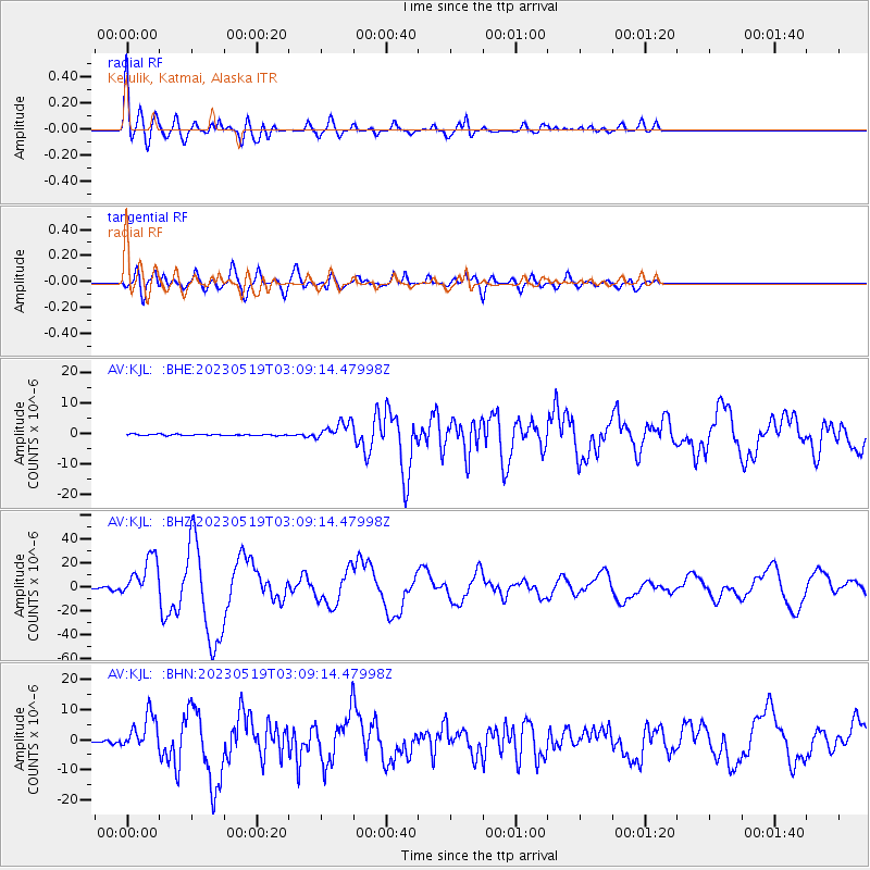
Signal To Noise
| Channel | StoN | STA | LTA |
| AV:KJL: :BHZ:20230519T03:09:14.47998Z | 62.011227 | 1.7148812E-5 | 2.7654366E-7 |
| AV:KJL: :BHN:20230519T03:09:14.47998Z | 27.100134 | 5.8830833E-6 | 2.1708688E-7 |
| AV:KJL: :BHE:20230519T03:09:14.47998Z | 14.026979 | 2.958924E-6 | 2.1094519E-7 |
| Arrivals |
| Ps | 4.5 SECOND |
| PpPs | 13 SECOND |
| PsPs/PpSs | 18 SECOND |


