You are here: Home > Network List > AV - Alaska Volcano Observatory Stations List
> Station MAPS Pakushin Southeast, Makushin Volcano, Alaska > Earthquake Result Viewer
MAPS Pakushin Southeast, Makushin Volcano, Alaska - Earthquake Result Viewer
| Earthquake location: |
Southeast Of Loyalty Islands |
| Earthquake latitude/longitude: |
-23.2/170.7 |
| Earthquake time(UTC): |
2023/05/19 (139) 02:57:07 GMT |
| Earthquake Depth: |
10 km |
| Earthquake Magnitude: |
7.7 Mi |
| Earthquake Catalog/Contributor: |
NEIC PDE/at |
|
| Network: |
AV Alaska Volcano Observatory |
| Station: |
MAPS Pakushin Southeast, Makushin Volcano, Alaska |
| Lat/Lon: |
53.81 N/166.94 W |
| Elevation: |
333 m |
|
| Distance: |
79.1 deg |
| Az: |
13.311 deg |
| Baz: |
200.928 deg |
| Ray Param: |
0.049201358 |
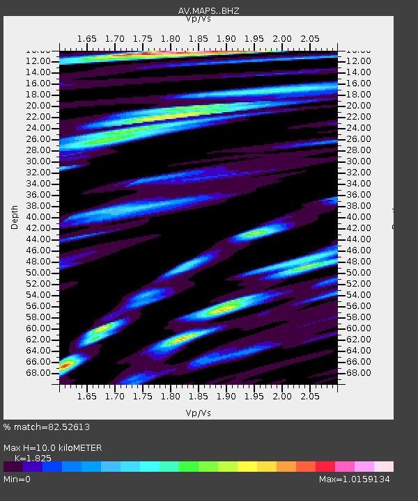
| Estimated Moho Depth: |
10.0 km |
| Estimated Crust Vp/Vs: |
1.83 |
| Assumed Crust Vp: |
3.943 km/s |
| Estimated Crust Vs: |
2.161 km/s |
| Estimated Crust Poisson's Ratio: |
0.29 |
|
| Radial Match: |
82.52613 % |
| Radial Bump: |
400 |
| Transverse Match: |
72.930275 % |
| Transverse Bump: |
400 |
| SOD ConfigId: |
30536071 |
| Insert Time: |
2023-06-02 03:06:49.154 +0000 |
| GWidth: |
2.5 |
| Max Bumps: |
400 |
| Tol: |
0.001 |
|

Signal To Noise
| Channel | StoN | STA | LTA |
| AV:MAPS: :BHZ:20230519T03:08:40.099976Z | 35.35155 | 1.0816397E-5 | 3.0596667E-7 |
| AV:MAPS: :BHN:20230519T03:08:40.099976Z | 12.139098 | 4.7548515E-6 | 3.9169726E-7 |
| AV:MAPS: :BHE:20230519T03:08:40.099976Z | 11.79279 | 3.8100568E-6 | 3.2308358E-7 |
| Arrivals |
| Ps | 2.1 SECOND |
| PpPs | 7.1 SECOND |
| PsPs/PpSs | 9.2 SECOND |


