You are here: Home > Network List > AV - Alaska Volcano Observatory Stations List
> Station MGLS Mageik Landslide, Katmai, Volcanic Group, Alaska > Earthquake Result Viewer
MGLS Mageik Landslide, Katmai, Volcanic Group, Alaska - Earthquake Result Viewer
| Earthquake location: |
Southeast Of Loyalty Islands |
| Earthquake latitude/longitude: |
-23.2/170.7 |
| Earthquake time(UTC): |
2023/05/19 (139) 02:57:07 GMT |
| Earthquake Depth: |
10 km |
| Earthquake Magnitude: |
7.7 Mi |
| Earthquake Catalog/Contributor: |
NEIC PDE/at |
|
| Network: |
AV Alaska Volcano Observatory |
| Station: |
MGLS Mageik Landslide, Katmai, Volcanic Group, Alaska |
| Lat/Lon: |
58.13 N/155.16 W |
| Elevation: |
472 m |
|
| Distance: |
85.9 deg |
| Az: |
17.388 deg |
| Baz: |
211.221 deg |
| Ray Param: |
0.044452287 |
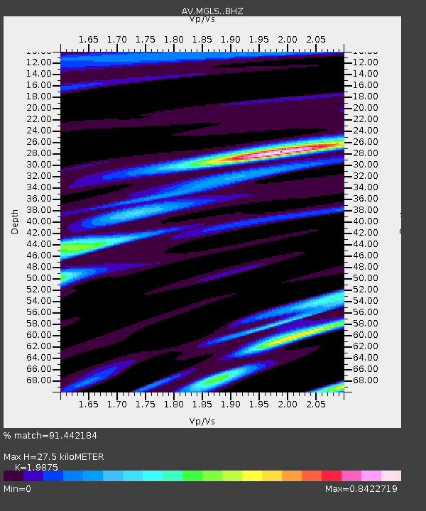
| Estimated Moho Depth: |
27.5 km |
| Estimated Crust Vp/Vs: |
1.99 |
| Assumed Crust Vp: |
6.438 km/s |
| Estimated Crust Vs: |
3.239 km/s |
| Estimated Crust Poisson's Ratio: |
0.33 |
|
| Radial Match: |
91.442184 % |
| Radial Bump: |
400 |
| Transverse Match: |
91.877655 % |
| Transverse Bump: |
400 |
| SOD ConfigId: |
30536071 |
| Insert Time: |
2023-06-02 03:06:52.534 +0000 |
| GWidth: |
2.5 |
| Max Bumps: |
400 |
| Tol: |
0.001 |
|

Signal To Noise
| Channel | StoN | STA | LTA |
| AV:MGLS: :BHZ:20230519T03:09:15.380005Z | 52.20165 | 1.4493259E-5 | 2.7763988E-7 |
| AV:MGLS: :BHN:20230519T03:09:15.380005Z | 26.855175 | 5.480274E-6 | 2.040677E-7 |
| AV:MGLS: :BHE:20230519T03:09:15.380005Z | 14.173982 | 2.0410819E-6 | 1.4400202E-7 |
| Arrivals |
| Ps | 4.3 SECOND |
| PpPs | 12 SECOND |
| PsPs/PpSs | 17 SECOND |


