You are here: Home > Network List > AV - Alaska Volcano Observatory Stations List
> Station MNAT Nateekin Bay, Makushin Volcano, Alaska > Earthquake Result Viewer
MNAT Nateekin Bay, Makushin Volcano, Alaska - Earthquake Result Viewer
| Earthquake location: |
Southeast Of Loyalty Islands |
| Earthquake latitude/longitude: |
-23.2/170.7 |
| Earthquake time(UTC): |
2023/05/19 (139) 02:57:07 GMT |
| Earthquake Depth: |
10 km |
| Earthquake Magnitude: |
7.7 Mi |
| Earthquake Catalog/Contributor: |
NEIC PDE/at |
|
| Network: |
AV Alaska Volcano Observatory |
| Station: |
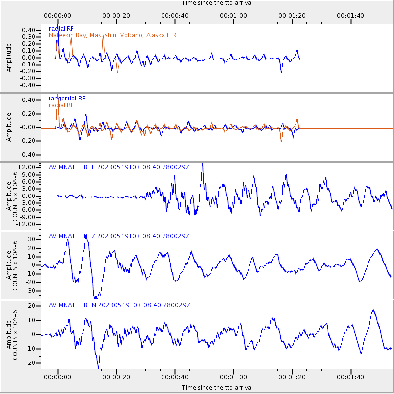
MNAT Nateekin Bay, Makushin Volcano, Alaska |
| Lat/Lon: |
53.88 N/166.69 W |
| Elevation: |
390 m |
|
| Distance: |
79.2 deg |
| Az: |
13.427 deg |
| Baz: |
201.156 deg |
| Ray Param: |
0.04911798 |
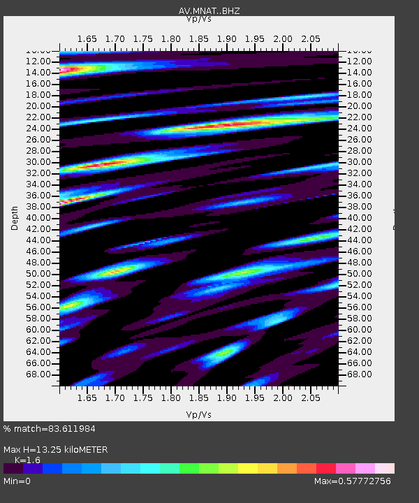
| Estimated Moho Depth: |
13.25 km |
| Estimated Crust Vp/Vs: |
1.60 |
| Assumed Crust Vp: |
3.943 km/s |
| Estimated Crust Vs: |
2.465 km/s |
| Estimated Crust Poisson's Ratio: |
0.18 |
|
| Radial Match: |
83.611984 % |
| Radial Bump: |
328 |
| Transverse Match: |
78.49627 % |
| Transverse Bump: |
400 |
| SOD ConfigId: |
30536071 |
| Insert Time: |
2023-06-02 03:06:55.687 +0000 |
| GWidth: |
2.5 |
| Max Bumps: |
400 |
| Tol: |
0.001 |
|
Signal To Noise
| Channel | StoN | STA | LTA |
| AV:MNAT: :BHZ:20230519T03:08:40.780029Z | 33.096745 | 1.4412032E-5 | 4.3545165E-7 |
| AV:MNAT: :BHN:20230519T03:08:40.780029Z | 14.232013 | 5.085979E-6 | 3.5736187E-7 |
| AV:MNAT: :BHE:20230519T03:08:40.780029Z | 5.970082 | 2.0614368E-6 | 3.4529458E-7 |
| Arrivals |
| Ps | 2.0 SECOND |
| PpPs | 8.6 SECOND |
| PsPs/PpSs | 11 SECOND |


