You are here: Home > Network List > AV - Alaska Volcano Observatory Stations List
> Station MTBL Table Top, Makushin Volcano, Alaska > Earthquake Result Viewer
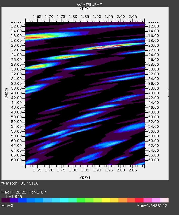
MTBL Table Top, Makushin Volcano, Alaska - Earthquake Result Viewer
| Earthquake location: |
Southeast Of Loyalty Islands |
| Earthquake latitude/longitude: |
-23.2/170.7 |
| Earthquake time(UTC): |
2023/05/19 (139) 02:57:07 GMT |
| Earthquake Depth: |
10 km |
| Earthquake Magnitude: |
7.7 Mi |
| Earthquake Catalog/Contributor: |
NEIC PDE/at |
|
| Network: |
AV Alaska Volcano Observatory |
| Station: |
MTBL Table Top, Makushin Volcano, Alaska |
| Lat/Lon: |
53.97 N/166.68 W |
| Elevation: |
810 m |
|
| Distance: |
79.3 deg |
| Az: |
13.398 deg |
| Baz: |
201.154 deg |
| Ray Param: |
0.049062997 |
| Estimated Moho Depth: |
20.25 km |
| Estimated Crust Vp/Vs: |
1.95 |
| Assumed Crust Vp: |
3.943 km/s |
| Estimated Crust Vs: |
2.027 km/s |
| Estimated Crust Poisson's Ratio: |
0.32 |
|
| Radial Match: |
83.45116 % |
| Radial Bump: |
400 |
| Transverse Match: |
77.48723 % |
| Transverse Bump: |
400 |
| SOD ConfigId: |
30536071 |
| Insert Time: |
2023-06-02 03:06:59.526 +0000 |
| GWidth: |
2.5 |
| Max Bumps: |
400 |
| Tol: |
0.001 |
|

Signal To Noise
| Channel | StoN | STA | LTA |
| AV:MTBL: :BHZ:20230519T03:08:41.218994Z | 26.271059 | 1.6806081E-5 | 6.3971845E-7 |
| AV:MTBL: :BHN:20230519T03:08:41.218994Z | 7.2724824 | 7.428273E-6 | 1.021422E-6 |
| AV:MTBL: :BHE:20230519T03:08:41.218994Z | 4.3803024 | 6.4193086E-6 | 1.4654944E-6 |
| Arrivals |
| Ps | 4.9 SECOND |
| PpPs | 15 SECOND |
| PsPs/PpSs | 20 SECOND |


