You are here: Home > Network List > AV - Alaska Volcano Observatory Stations List
> Station R17L Mt. Peulik Volcano, AVO PLK4, AK, USA > Earthquake Result Viewer
R17L Mt. Peulik Volcano, AVO PLK4, AK, USA - Earthquake Result Viewer
| Earthquake location: |
Southeast Of Loyalty Islands |
| Earthquake latitude/longitude: |
-23.2/170.7 |
| Earthquake time(UTC): |
2023/05/19 (139) 02:57:07 GMT |
| Earthquake Depth: |
10 km |
| Earthquake Magnitude: |
7.7 Mi |
| Earthquake Catalog/Contributor: |
NEIC PDE/at |
|
| Network: |
AV Alaska Volcano Observatory |
| Station: |
R17L Mt. Peulik Volcano, AVO PLK4, AK, USA |
| Lat/Lon: |
57.63 N/156.36 W |
| Elevation: |
524 m |
|
| Distance: |
85.1 deg |
| Az: |
17.095 deg |
| Baz: |
210.186 deg |
| Ray Param: |
0.044996265 |
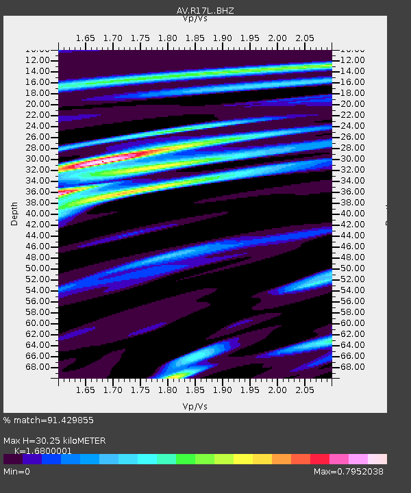
| Estimated Moho Depth: |
30.25 km |
| Estimated Crust Vp/Vs: |
1.68 |
| Assumed Crust Vp: |
6.1 km/s |
| Estimated Crust Vs: |
3.631 km/s |
| Estimated Crust Poisson's Ratio: |
0.23 |
|
| Radial Match: |
91.429855 % |
| Radial Bump: |
400 |
| Transverse Match: |
84.70233 % |
| Transverse Bump: |
400 |
| SOD ConfigId: |
30536071 |
| Insert Time: |
2023-06-02 03:07:29.501 +0000 |
| GWidth: |
2.5 |
| Max Bumps: |
400 |
| Tol: |
0.001 |
|

Signal To Noise
| Channel | StoN | STA | LTA |
| AV:R17L: :BHZ:20230519T03:09:11.599976Z | 83.546364 | 1.8710352E-5 | 2.2395173E-7 |
| AV:R17L: :BHN:20230519T03:09:11.599976Z | 26.18746 | 4.5809525E-6 | 1.7492924E-7 |
| AV:R17L: :BHE:20230519T03:09:11.599976Z | 11.524772 | 2.532051E-6 | 2.197051E-7 |
| Arrivals |
| Ps | 3.5 SECOND |
| PpPs | 13 SECOND |
| PsPs/PpSs | 16 SECOND |


