You are here: Home > Network List > AV - Alaska Volcano Observatory Stations List
> Station SPCR Ckakachatna River, Mount Spurr, Alaska > Earthquake Result Viewer
SPCR Ckakachatna River, Mount Spurr, Alaska - Earthquake Result Viewer
| Earthquake location: |
Southeast Of Loyalty Islands |
| Earthquake latitude/longitude: |
-23.2/170.7 |
| Earthquake time(UTC): |
2023/05/19 (139) 02:57:07 GMT |
| Earthquake Depth: |
10 km |
| Earthquake Magnitude: |
7.7 Mi |
| Earthquake Catalog/Contributor: |
NEIC PDE/at |
|
| Network: |
AV Alaska Volcano Observatory |
| Station: |
SPCR Ckakachatna River, Mount Spurr, Alaska |
| Lat/Lon: |
61.20 N/152.21 W |
| Elevation: |
984 m |
|
| Distance: |
89.3 deg |
| Az: |
17.001 deg |
| Baz: |
213.75 deg |
| Ray Param: |
0.04197048 |
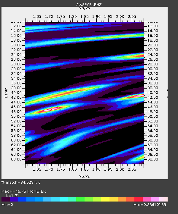
| Estimated Moho Depth: |
46.75 km |
| Estimated Crust Vp/Vs: |
1.71 |
| Assumed Crust Vp: |
6.566 km/s |
| Estimated Crust Vs: |
3.84 km/s |
| Estimated Crust Poisson's Ratio: |
0.24 |
|
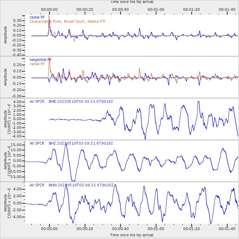
| Radial Match: |
84.023476 % |
| Radial Bump: |
400 |
| Transverse Match: |
79.85095 % |
| Transverse Bump: |
400 |
| SOD ConfigId: |
30536071 |
| Insert Time: |
2023-06-02 03:07:48.648 +0000 |
| GWidth: |
2.5 |
| Max Bumps: |
400 |
| Tol: |
0.001 |
|
Signal To Noise
| Channel | StoN | STA | LTA |
| AV:SPCR: :BHZ:20230519T03:09:31.679016Z | 33.12927 | 6.7730184E-6 | 2.0444214E-7 |
| AV:SPCR: :BHN:20230519T03:09:31.679016Z | 25.116478 | 1.9507431E-6 | 7.7667856E-8 |
| AV:SPCR: :BHE:20230519T03:09:31.679016Z | 11.591559 | 9.7342E-7 | 8.3976616E-8 |
| Arrivals |
| Ps | 5.2 SECOND |
| PpPs | 19 SECOND |
| PsPs/PpSs | 24 SECOND |


