You are here: Home > Network List > AV - Alaska Volcano Observatory Stations List
> Station WESP Westdahl Peak, Westdahl Peak, Alaska > Earthquake Result Viewer
WESP Westdahl Peak, Westdahl Peak, Alaska - Earthquake Result Viewer
| Earthquake location: |
Southeast Of Loyalty Islands |
| Earthquake latitude/longitude: |
-23.2/170.7 |
| Earthquake time(UTC): |
2023/05/19 (139) 02:57:07 GMT |
| Earthquake Depth: |
10 km |
| Earthquake Magnitude: |
7.7 Mi |
| Earthquake Catalog/Contributor: |
NEIC PDE/at |
|
| Network: |
AV Alaska Volcano Observatory |
| Station: |
WESP Westdahl Peak, Westdahl Peak, Alaska |
| Lat/Lon: |
54.49 N/164.72 W |
| Elevation: |
937 m |
|
| Distance: |
80.2 deg |
| Az: |
14.281 deg |
| Baz: |
202.896 deg |
| Ray Param: |
0.048434086 |
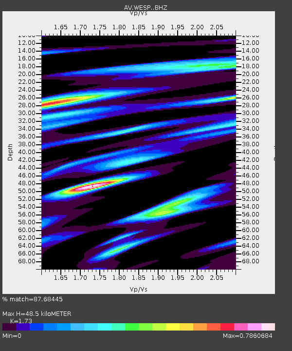
| Estimated Moho Depth: |
48.5 km |
| Estimated Crust Vp/Vs: |
1.73 |
| Assumed Crust Vp: |
5.989 km/s |
| Estimated Crust Vs: |
3.462 km/s |
| Estimated Crust Poisson's Ratio: |
0.25 |
|
| Radial Match: |
87.68445 % |
| Radial Bump: |
400 |
| Transverse Match: |
66.03047 % |
| Transverse Bump: |
400 |
| SOD ConfigId: |
30536071 |
| Insert Time: |
2023-06-02 03:08:24.800 +0000 |
| GWidth: |
2.5 |
| Max Bumps: |
400 |
| Tol: |
0.001 |
|

Signal To Noise
| Channel | StoN | STA | LTA |
| AV:WESP: :BHZ:20230519T03:08:46.179993Z | 15.391334 | 1.725713E-5 | 1.1212238E-6 |
| AV:WESP: :BHN:20230519T03:08:46.179993Z | 7.72547 | 7.681549E-6 | 9.943147E-7 |
| AV:WESP: :BHE:20230519T03:08:46.179993Z | 2.596293 | 3.8956314E-6 | 1.500459E-6 |
| Arrivals |
| Ps | 6.1 SECOND |
| PpPs | 22 SECOND |
| PsPs/PpSs | 28 SECOND |


