You are here: Home > Network List > AZ - ANZA Regional Network Stations List
> Station SIO5 Mt. Soledad, La Jolla, CA > Earthquake Result Viewer
SIO5 Mt. Soledad, La Jolla, CA - Earthquake Result Viewer
| Earthquake location: |
Southeast Of Loyalty Islands |
| Earthquake latitude/longitude: |
-23.2/170.7 |
| Earthquake time(UTC): |
2023/05/19 (139) 02:57:07 GMT |
| Earthquake Depth: |
10 km |
| Earthquake Magnitude: |
7.7 Mi |
| Earthquake Catalog/Contributor: |
NEIC PDE/at |
|
| Network: |
AZ ANZA Regional Network |
| Station: |
SIO5 Mt. Soledad, La Jolla, CA |
| Lat/Lon: |
32.84 N/117.25 W |
| Elevation: |
217 m |
|
| Distance: |
88.5 deg |
| Az: |
53.261 deg |
| Baz: |
241.152 deg |
| Ray Param: |
0.042565472 |
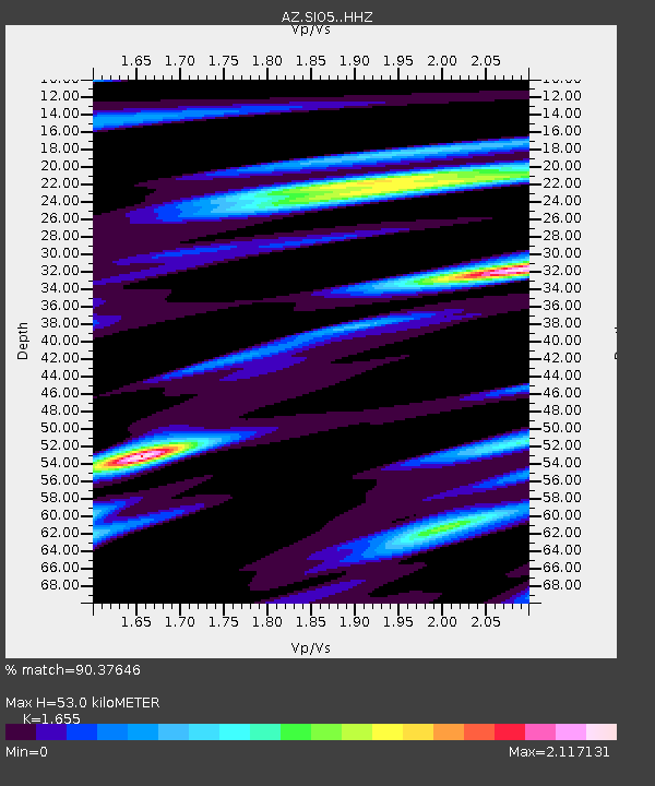
| Estimated Moho Depth: |
53.0 km |
| Estimated Crust Vp/Vs: |
1.65 |
| Assumed Crust Vp: |
6.264 km/s |
| Estimated Crust Vs: |
3.785 km/s |
| Estimated Crust Poisson's Ratio: |
0.21 |
|
| Radial Match: |
90.37646 % |
| Radial Bump: |
400 |
| Transverse Match: |
86.01068 % |
| Transverse Bump: |
400 |
| SOD ConfigId: |
30536071 |
| Insert Time: |
2023-06-02 03:08:43.138 +0000 |
| GWidth: |
2.5 |
| Max Bumps: |
400 |
| Tol: |
0.001 |
|

Signal To Noise
| Channel | StoN | STA | LTA |
| AZ:SIO5: :HHZ:20230519T03:09:27.862976Z | 23.659964 | 7.38047E-6 | 3.1193917E-7 |
| AZ:SIO5: :HHN:20230519T03:09:27.862976Z | 1.6745825 | 1.0808255E-6 | 6.454299E-7 |
| AZ:SIO5: :HHE:20230519T03:09:27.862976Z | 3.851551 | 2.638887E-6 | 6.851492E-7 |
| Arrivals |
| Ps | 5.7 SECOND |
| PpPs | 22 SECOND |
| PsPs/PpSs | 28 SECOND |


