You are here: Home > Network List > CC - Cascade Chain Volcano Monitoring Stations List
> Station CRBN Carbon River Ranger Station > Earthquake Result Viewer
CRBN Carbon River Ranger Station - Earthquake Result Viewer
| Earthquake location: |
Southeast Of Loyalty Islands |
| Earthquake latitude/longitude: |
-23.2/170.7 |
| Earthquake time(UTC): |
2023/05/19 (139) 02:57:07 GMT |
| Earthquake Depth: |
10 km |
| Earthquake Magnitude: |
7.7 Mi |
| Earthquake Catalog/Contributor: |
NEIC PDE/at |
|
| Network: |
CC Cascade Chain Volcano Monitoring |
| Station: |
CRBN Carbon River Ranger Station |
| Lat/Lon: |
46.99 N/121.96 W |
| Elevation: |
500 m |
|
| Distance: |
92.5 deg |
| Az: |
39.239 deg |
| Baz: |
238.233 deg |
| Ray Param: |
0.041451477 |
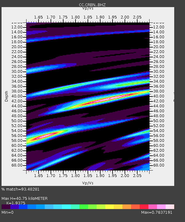
| Estimated Moho Depth: |
40.75 km |
| Estimated Crust Vp/Vs: |
1.94 |
| Assumed Crust Vp: |
6.597 km/s |
| Estimated Crust Vs: |
3.405 km/s |
| Estimated Crust Poisson's Ratio: |
0.32 |
|
| Radial Match: |
93.48281 % |
| Radial Bump: |
400 |
| Transverse Match: |
77.37128 % |
| Transverse Bump: |
400 |
| SOD ConfigId: |
30536071 |
| Insert Time: |
2023-06-02 03:10:34.051 +0000 |
| GWidth: |
2.5 |
| Max Bumps: |
400 |
| Tol: |
0.001 |
|

Signal To Noise
| Channel | StoN | STA | LTA |
| CC:CRBN: :BHZ:20230519T03:09:46.47998Z | 48.688396 | 5.122845E-6 | 1.05216955E-7 |
| CC:CRBN: :BHN:20230519T03:09:46.47998Z | 12.06957 | 7.370417E-7 | 6.106612E-8 |
| CC:CRBN: :BHE:20230519T03:09:46.47998Z | 14.860492 | 1.3618939E-6 | 9.164527E-8 |
| Arrivals |
| Ps | 5.9 SECOND |
| PpPs | 18 SECOND |
| PsPs/PpSs | 24 SECOND |


