You are here: Home > Network List > TA - USArray Transportable Network (new EarthScope stations) Stations List
> Station 332A Millersview, TX, USA > Earthquake Result Viewer
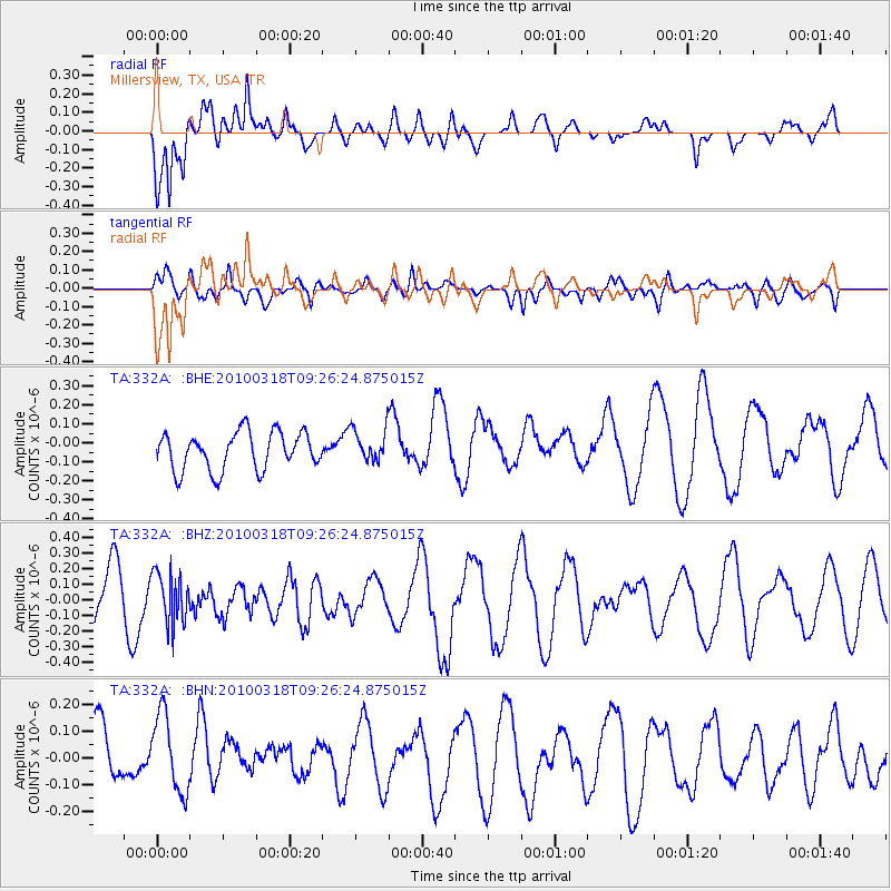
332A Millersview, TX, USA - Earthquake Result Viewer
*The percent match for this event was below the threshold and hence no stack was calculated.
| Earthquake location: |
South Of Fiji Islands |
| Earthquake latitude/longitude: |
-23.3/-177.2 |
| Earthquake time(UTC): |
2010/03/18 (077) 09:14:05 GMT |
| Earthquake Depth: |
158 km |
| Earthquake Magnitude: |
5.6 MW, 5.2 MB, 5.5 MW |
| Earthquake Catalog/Contributor: |
WHDF/NEIC |
|
| Network: |
TA USArray Transportable Network (new EarthScope stations) |
| Station: |
332A Millersview, TX, USA |
| Lat/Lon: |
31.38 N/99.74 W |
| Elevation: |
513 m |
|
| Distance: |
91.9 deg |
| Az: |
56.639 deg |
| Baz: |
243.864 deg |
| Ray Param: |
$rayparam |
*The percent match for this event was below the threshold and hence was not used in the summary stack. |
|
| Radial Match: |
68.263504 % |
| Radial Bump: |
400 |
| Transverse Match: |
27.781708 % |
| Transverse Bump: |
388 |
| SOD ConfigId: |
308276 |
| Insert Time: |
2010-06-22 21:25:35.020 +0000 |
| GWidth: |
2.5 |
| Max Bumps: |
400 |
| Tol: |
0.001 |
|
Signal To Noise
| Channel | StoN | STA | LTA |
| TA:332A: :BHZ:20100318T09:26:24.875015Z | 0.9672621 | 1.6253333E-7 | 1.6803442E-7 |
| TA:332A: :BHN:20100318T09:26:24.875015Z | 0.8702279 | 1.5841363E-7 | 1.8203696E-7 |
| TA:332A: :BHE:20100318T09:26:24.875015Z | 0.89075905 | 8.842364E-8 | 9.926774E-8 |
| Arrivals |
| Ps | |
| PpPs | |
| PsPs/PpSs | |


