You are here: Home > Network List > TA - USArray Transportable Network (new EarthScope stations) Stations List
> Station 232A Coleman, TX, USA > Earthquake Result Viewer
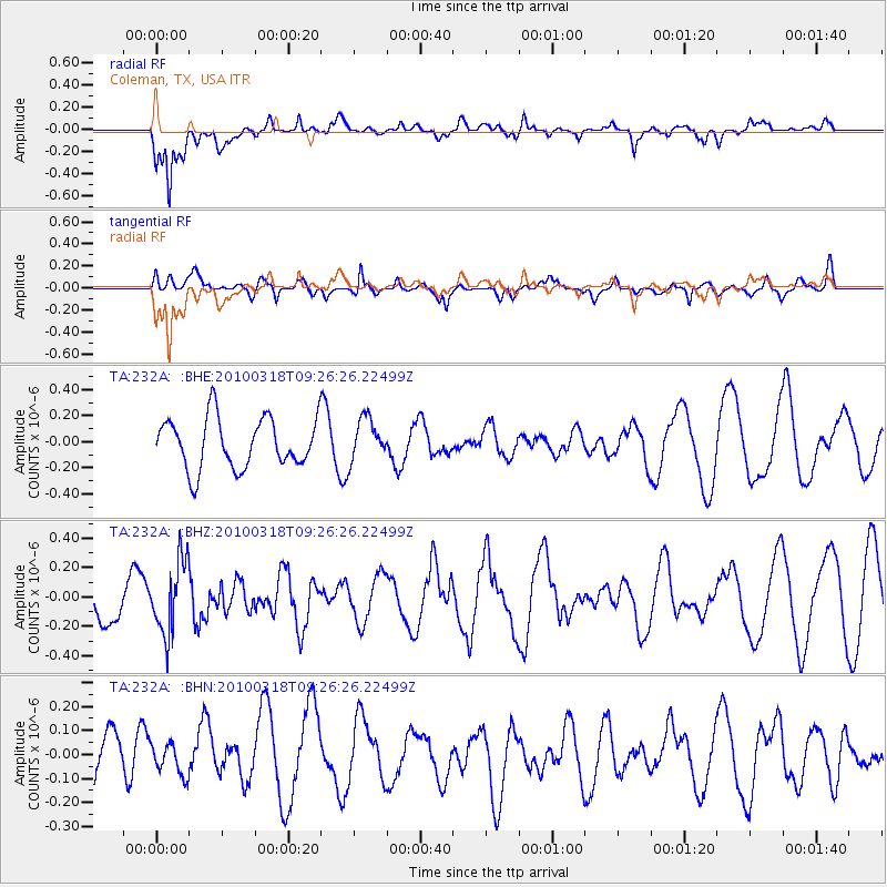
232A Coleman, TX, USA - Earthquake Result Viewer
*The percent match for this event was below the threshold and hence no stack was calculated.
| Earthquake location: |
South Of Fiji Islands |
| Earthquake latitude/longitude: |
-23.3/-177.2 |
| Earthquake time(UTC): |
2010/03/18 (077) 09:14:05 GMT |
| Earthquake Depth: |
158 km |
| Earthquake Magnitude: |
5.6 MW, 5.2 MB, 5.5 MW |
| Earthquake Catalog/Contributor: |
WHDF/NEIC |
|
| Network: |
TA USArray Transportable Network (new EarthScope stations) |
| Station: |
232A Coleman, TX, USA |
| Lat/Lon: |
31.89 N/99.65 W |
| Elevation: |
621 m |
|
| Distance: |
92.2 deg |
| Az: |
56.222 deg |
| Baz: |
243.929 deg |
| Ray Param: |
$rayparam |
*The percent match for this event was below the threshold and hence was not used in the summary stack. |
|
| Radial Match: |
83.54749 % |
| Radial Bump: |
400 |
| Transverse Match: |
69.27226 % |
| Transverse Bump: |
400 |
| SOD ConfigId: |
308276 |
| Insert Time: |
2010-06-22 21:25:35.475 +0000 |
| GWidth: |
2.5 |
| Max Bumps: |
400 |
| Tol: |
0.001 |
|
Signal To Noise
| Channel | StoN | STA | LTA |
| TA:232A: :BHZ:20100318T09:26:26.22499Z | 1.0820949 | 2.4740163E-7 | 2.2863209E-7 |
| TA:232A: :BHN:20100318T09:26:26.22499Z | 0.46891218 | 6.336003E-8 | 1.3512131E-7 |
| TA:232A: :BHE:20100318T09:26:26.22499Z | 0.83715206 | 1.6181232E-7 | 1.9328904E-7 |
| Arrivals |
| Ps | |
| PpPs | |
| PsPs/PpSs | |


