You are here: Home > Network List > TA - USArray Transportable Network (new EarthScope stations) Stations List
> Station I28A Midland, SD, USA > Earthquake Result Viewer
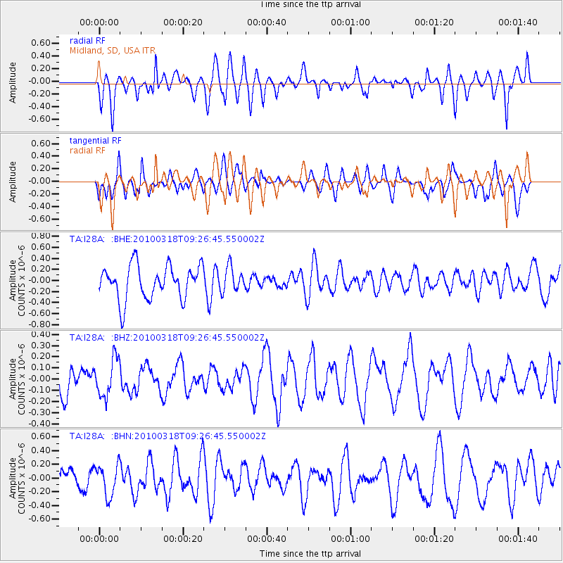
I28A Midland, SD, USA - Earthquake Result Viewer
*The percent match for this event was below the threshold and hence no stack was calculated.
| Earthquake location: |
South Of Fiji Islands |
| Earthquake latitude/longitude: |
-23.3/-177.2 |
| Earthquake time(UTC): |
2010/03/18 (077) 09:14:05 GMT |
| Earthquake Depth: |
158 km |
| Earthquake Magnitude: |
5.6 MW, 5.2 MB, 5.5 MW |
| Earthquake Catalog/Contributor: |
WHDF/NEIC |
|
| Network: |
TA USArray Transportable Network (new EarthScope stations) |
| Station: |
I28A Midland, SD, USA |
| Lat/Lon: |
44.00 N/101.17 W |
| Elevation: |
655 m |
|
| Distance: |
96.4 deg |
| Az: |
44.805 deg |
| Baz: |
243.852 deg |
| Ray Param: |
$rayparam |
*The percent match for this event was below the threshold and hence was not used in the summary stack. |
|
| Radial Match: |
62.73349 % |
| Radial Bump: |
400 |
| Transverse Match: |
48.695404 % |
| Transverse Bump: |
400 |
| SOD ConfigId: |
308276 |
| Insert Time: |
2010-06-22 21:26:03.645 +0000 |
| GWidth: |
2.5 |
| Max Bumps: |
400 |
| Tol: |
0.001 |
|
Signal To Noise
| Channel | StoN | STA | LTA |
| TA:I28A: :BHZ:20100318T09:26:45.550002Z | 0.9207752 | 1.7279943E-7 | 1.8766734E-7 |
| TA:I28A: :BHN:20100318T09:26:45.550002Z | 0.97155726 | 2.3635894E-7 | 2.4327844E-7 |
| TA:I28A: :BHE:20100318T09:26:45.550002Z | 0.74927497 | 2.2727012E-7 | 3.0332004E-7 |
| Arrivals |
| Ps | |
| PpPs | |
| PsPs/PpSs | |


