You are here: Home > Network List > CI - Caltech Regional Seismic Network Stations List
> Station MPP McPhearson Peak > Earthquake Result Viewer
MPP McPhearson Peak - Earthquake Result Viewer
| Earthquake location: |
Southeast Of Loyalty Islands |
| Earthquake latitude/longitude: |
-23.2/170.7 |
| Earthquake time(UTC): |
2023/05/19 (139) 02:57:07 GMT |
| Earthquake Depth: |
10 km |
| Earthquake Magnitude: |
7.7 Mi |
| Earthquake Catalog/Contributor: |
NEIC PDE/at |
|
| Network: |
CI Caltech Regional Seismic Network |
| Station: |
MPP McPhearson Peak |
| Lat/Lon: |
34.89 N/119.81 W |
| Elevation: |
1739 m |
|
| Distance: |
87.6 deg |
| Az: |
50.429 deg |
| Baz: |
239.633 deg |
| Ray Param: |
0.043193985 |
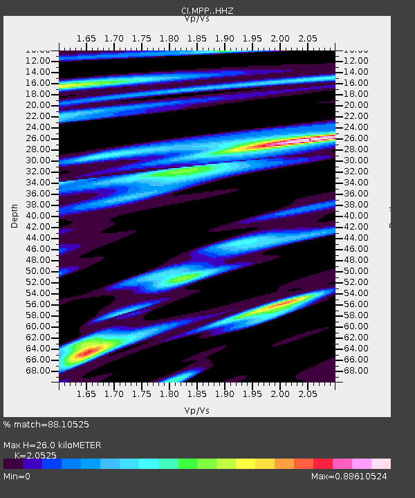
| Estimated Moho Depth: |
26.0 km |
| Estimated Crust Vp/Vs: |
2.05 |
| Assumed Crust Vp: |
6.1 km/s |
| Estimated Crust Vs: |
2.972 km/s |
| Estimated Crust Poisson's Ratio: |
0.34 |
|
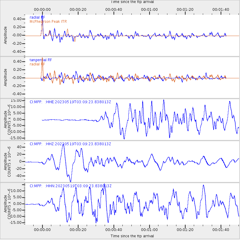
| Radial Match: |
88.10525 % |
| Radial Bump: |
400 |
| Transverse Match: |
88.894806 % |
| Transverse Bump: |
400 |
| SOD ConfigId: |
30536071 |
| Insert Time: |
2023-06-02 03:12:41.388 +0000 |
| GWidth: |
2.5 |
| Max Bumps: |
400 |
| Tol: |
0.001 |
|
Signal To Noise
| Channel | StoN | STA | LTA |
| CI:MPP: :HHZ:20230519T03:09:23.838013Z | 26.282333 | 6.092445E-6 | 2.318076E-7 |
| CI:MPP: :HHN:20230519T03:09:23.838013Z | 8.456188 | 1.3830509E-6 | 1.6355487E-7 |
| CI:MPP: :HHE:20230519T03:09:23.838013Z | 6.7317815 | 1.3570209E-6 | 2.0158421E-7 |
| Arrivals |
| Ps | 4.6 SECOND |
| PpPs | 13 SECOND |
| PsPs/PpSs | 17 SECOND |


