You are here: Home > Network List > CN - Canadian National Seismograph Network Stations List
> Station MGRB Mount Grey, BC, CA > Earthquake Result Viewer
MGRB Mount Grey, BC, CA - Earthquake Result Viewer
| Earthquake location: |
Southeast Of Loyalty Islands |
| Earthquake latitude/longitude: |
-23.2/170.7 |
| Earthquake time(UTC): |
2023/05/19 (139) 02:57:07 GMT |
| Earthquake Depth: |
10 km |
| Earthquake Magnitude: |
7.7 Mi |
| Earthquake Catalog/Contributor: |
NEIC PDE/at |
|
| Network: |
CN Canadian National Seismograph Network |
| Station: |
MGRB Mount Grey, BC, CA |
| Lat/Lon: |
49.00 N/124.70 W |
| Elevation: |
1310 m |
|
| Distance: |
92.0 deg |
| Az: |
36.551 deg |
| Baz: |
236.311 deg |
| Ray Param: |
0.041526247 |
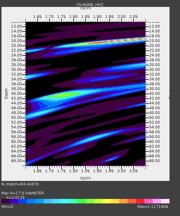
| Estimated Moho Depth: |
17.5 km |
| Estimated Crust Vp/Vs: |
2.01 |
| Assumed Crust Vp: |
6.391 km/s |
| Estimated Crust Vs: |
3.175 km/s |
| Estimated Crust Poisson's Ratio: |
0.34 |
|
| Radial Match: |
94.44678 % |
| Radial Bump: |
400 |
| Transverse Match: |
85.44201 % |
| Transverse Bump: |
400 |
| SOD ConfigId: |
30536071 |
| Insert Time: |
2023-06-02 03:14:32.872 +0000 |
| GWidth: |
2.5 |
| Max Bumps: |
400 |
| Tol: |
0.001 |
|

Signal To Noise
| Channel | StoN | STA | LTA |
| CN:MGRB: :HHZ:20230519T03:09:44.359985Z | 46.87871 | 5.230256E-6 | 1.1156997E-7 |
| CN:MGRB: :HHN:20230519T03:09:44.359985Z | 10.967607 | 1.1816976E-6 | 1.0774435E-7 |
| CN:MGRB: :HHE:20230519T03:09:44.359985Z | 19.380997 | 1.8175934E-6 | 9.378225E-8 |
| Arrivals |
| Ps | 2.8 SECOND |
| PpPs | 8.1 SECOND |
| PsPs/PpSs | 11 SECOND |


