You are here: Home > Network List > AK - Alaska Regional Network Stations List
> Station COLD Coldfoot Broadband > Earthquake Result Viewer
COLD Coldfoot Broadband - Earthquake Result Viewer

| Earthquake location: |
New Ireland Region, P.N.G. |
| Earthquake latitude/longitude: |
-3.4/152.2 |
| Earthquake time(UTC): |
2010/03/20 (079) 14:00:49 GMT |
| Earthquake Depth: |
415 km |
| Earthquake Magnitude: |
6.0 MB, 6.6 MW, 6.5 MW |
| Earthquake Catalog/Contributor: |
WHDF/NEIC |
|
| Network: |
AK Alaska Regional Network |
| Station: |
COLD Coldfoot Broadband |
| Lat/Lon: |
67.23 N/150.20 W |
| Elevation: |
377 m |
|
| Distance: |
81.1 deg |
| Az: |
19.422 deg |
| Baz: |
238.512 deg |
| Ray Param: |
0.04667442 |
| Estimated Moho Depth: |
10.0 km |
| Estimated Crust Vp/Vs: |
2.05 |
| Assumed Crust Vp: |
6.577 km/s |
| Estimated Crust Vs: |
3.208 km/s |
| Estimated Crust Poisson's Ratio: |
0.34 |
|
| Radial Match: |
90.95623 % |
| Radial Bump: |
384 |
| Transverse Match: |
64.68059 % |
| Transverse Bump: |
400 |
| SOD ConfigId: |
308276 |
| Insert Time: |
2010-06-22 21:30:32.299 +0000 |
| GWidth: |
2.5 |
| Max Bumps: |
400 |
| Tol: |
0.001 |
|
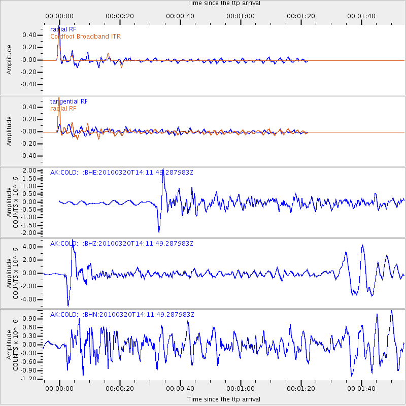
Signal To Noise
| Channel | StoN | STA | LTA |
| AK:COLD: :BHZ:20100320T14:11:49.287983Z | 25.28923 | 2.30568E-6 | 9.11724E-8 |
| AK:COLD: :BHN:20100320T14:11:49.287983Z | 3.72125 | 2.9662948E-7 | 7.971232E-8 |
| AK:COLD: :BHE:20100320T14:11:49.287983Z | 11.320691 | 9.0422674E-7 | 7.9873814E-8 |
| Arrivals |
| Ps | 1.6 SECOND |
| PpPs | 4.5 SECOND |
| PsPs/PpSs | 6.2 SECOND |


