You are here: Home > Network List > MM - Myanmar National Seismic Network Stations List
> Station KTN Keng Tun, Shan, Myanmar > Earthquake Result Viewer
KTN Keng Tun, Shan, Myanmar - Earthquake Result Viewer
| Earthquake location: |
Southeast Of Loyalty Islands |
| Earthquake latitude/longitude: |
-23.2/170.7 |
| Earthquake time(UTC): |
2023/05/19 (139) 02:57:07 GMT |
| Earthquake Depth: |
10 km |
| Earthquake Magnitude: |
7.7 Mi |
| Earthquake Catalog/Contributor: |
NEIC PDE/at |
|
| Network: |
MM Myanmar National Seismic Network |
| Station: |
KTN Keng Tun, Shan, Myanmar |
| Lat/Lon: |
21.29 N/99.59 E |
| Elevation: |
832 m |
|
| Distance: |
82.1 deg |
| Az: |
297.059 deg |
| Baz: |
118.522 deg |
| Ray Param: |
0.047112938 |
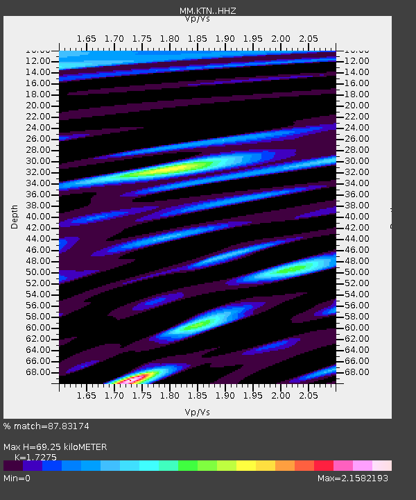
| Estimated Moho Depth: |
69.25 km |
| Estimated Crust Vp/Vs: |
1.73 |
| Assumed Crust Vp: |
6.316 km/s |
| Estimated Crust Vs: |
3.656 km/s |
| Estimated Crust Poisson's Ratio: |
0.25 |
|
| Radial Match: |
87.83174 % |
| Radial Bump: |
400 |
| Transverse Match: |
71.16327 % |
| Transverse Bump: |
400 |
| SOD ConfigId: |
30536071 |
| Insert Time: |
2023-06-02 03:18:50.053 +0000 |
| GWidth: |
2.5 |
| Max Bumps: |
400 |
| Tol: |
0.001 |
|

Signal To Noise
| Channel | StoN | STA | LTA |
| MM:KTN: :HHZ:20230519T03:08:56.247986Z | 35.669563 | 2.1340737E-5 | 5.9828983E-7 |
| MM:KTN: :HHN:20230519T03:08:56.247986Z | 11.504425 | 7.469051E-6 | 6.492329E-7 |
| MM:KTN: :HHE:20230519T03:08:56.247986Z | 21.067595 | 1.043439E-5 | 4.952815E-7 |
| Arrivals |
| Ps | 8.2 SECOND |
| PpPs | 29 SECOND |
| PsPs/PpSs | 37 SECOND |


