You are here: Home > Network List > NN - Western Great Basin/Eastern Sierra Nevada Stations List
> Station TBRD Thunderbird Lodge, Lake Tahoe, NV > Earthquake Result Viewer
TBRD Thunderbird Lodge, Lake Tahoe, NV - Earthquake Result Viewer
| Earthquake location: |
Southeast Of Loyalty Islands |
| Earthquake latitude/longitude: |
-23.2/170.7 |
| Earthquake time(UTC): |
2023/05/19 (139) 02:57:07 GMT |
| Earthquake Depth: |
10 km |
| Earthquake Magnitude: |
7.7 Mi |
| Earthquake Catalog/Contributor: |
NEIC PDE/at |
|
| Network: |
NN Western Great Basin/Eastern Sierra Nevada |
| Station: |
TBRD Thunderbird Lodge, Lake Tahoe, NV |
| Lat/Lon: |
39.17 N/119.93 W |
| Elevation: |
1952 m |
|
| Distance: |
89.7 deg |
| Az: |
46.694 deg |
| Baz: |
239.475 deg |
| Ray Param: |
0.041732684 |
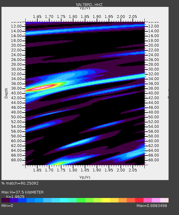
| Estimated Moho Depth: |
37.5 km |
| Estimated Crust Vp/Vs: |
1.66 |
| Assumed Crust Vp: |
6.279 km/s |
| Estimated Crust Vs: |
3.777 km/s |
| Estimated Crust Poisson's Ratio: |
0.22 |
|
| Radial Match: |
90.25092 % |
| Radial Bump: |
400 |
| Transverse Match: |
86.29883 % |
| Transverse Bump: |
400 |
| SOD ConfigId: |
30536071 |
| Insert Time: |
2023-06-02 03:19:53.322 +0000 |
| GWidth: |
2.5 |
| Max Bumps: |
400 |
| Tol: |
0.001 |
|

Signal To Noise
| Channel | StoN | STA | LTA |
| NN:TBRD: :HHZ:20230519T03:09:33.66803Z | 50.473957 | 5.4227507E-6 | 1.07436605E-7 |
| NN:TBRD: :HHN:20230519T03:09:33.66803Z | 6.4963875 | 7.095493E-7 | 1.0922213E-7 |
| NN:TBRD: :HHE:20230519T03:09:33.66803Z | 12.660549 | 1.2780096E-6 | 1.0094425E-7 |
| Arrivals |
| Ps | 4.0 SECOND |
| PpPs | 16 SECOND |
| PsPs/PpSs | 20 SECOND |


