You are here: Home > Network List > IU - Global Seismograph Network (GSN - IRIS/USGS) Stations List
> Station MAKZ Makanchi, Kazakhstan > Earthquake Result Viewer
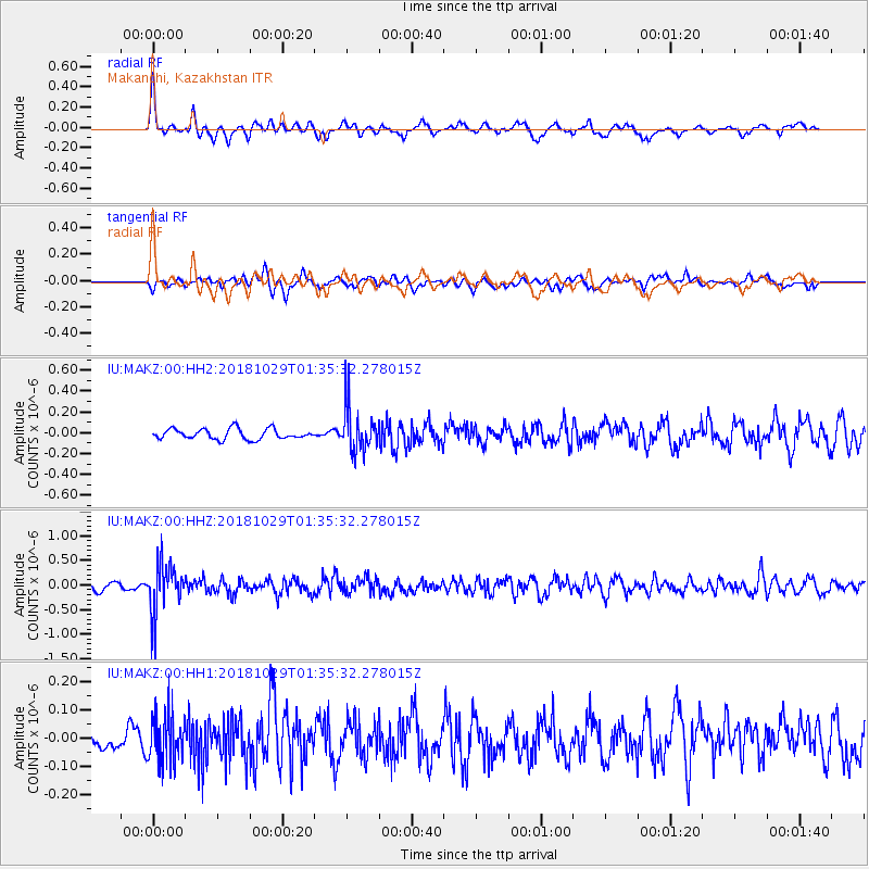
MAKZ Makanchi, Kazakhstan - Earthquake Result Viewer
*The percent match for this event was below the threshold and hence no stack was calculated.
| Earthquake location: |
Southeast Of Honshu, Japan |
| Earthquake latitude/longitude: |
31.6/140.2 |
| Earthquake time(UTC): |
2018/10/29 (302) 01:27:44 GMT |
| Earthquake Depth: |
94 km |
| Earthquake Magnitude: |
5.5 Mww |
| Earthquake Catalog/Contributor: |
NEIC PDE/us |
|
| Network: |
IU Global Seismograph Network (GSN - IRIS/USGS) |
| Station: |
MAKZ Makanchi, Kazakhstan |
| Lat/Lon: |
46.81 N/81.98 E |
| Elevation: |
600 m |
|
| Distance: |
46.6 deg |
| Az: |
306.475 deg |
| Baz: |
87.496 deg |
| Ray Param: |
$rayparam |
*The percent match for this event was below the threshold and hence was not used in the summary stack. |
|
| Radial Match: |
71.43806 % |
| Radial Bump: |
328 |
| Transverse Match: |
57.39691 % |
| Transverse Bump: |
400 |
| SOD ConfigId: |
3103472 |
| Insert Time: |
2018-11-12 01:37:06.578 +0000 |
| GWidth: |
2.5 |
| Max Bumps: |
400 |
| Tol: |
0.001 |
|
Signal To Noise
| Channel | StoN | STA | LTA |
| IU:MAKZ:00:HHZ:20181029T01:35:32.278015Z | 6.91593 | 4.914182E-7 | 7.105598E-8 |
| IU:MAKZ:00:HH1:20181029T01:35:32.278015Z | 2.3319728 | 8.6012065E-8 | 3.688382E-8 |
| IU:MAKZ:00:HH2:20181029T01:35:32.278015Z | 4.1013923 | 2.030444E-7 | 4.9506212E-8 |
| Arrivals |
| Ps | |
| PpPs | |
| PsPs/PpSs | |


